fortres ridge canyon exit

fortres ridge canyon exit


Info

walking distance: 9.5 km
duration: 6:51 h
walking: 2:55 h
elevation diff: 606 m
location: blue mountains
driving distance: km
driving time: 1.5 h
water available: yes
parking: -33.6583,150.3643


gps tracks

Total distance: 9730 m
Max elevation: 955 m
Min elevation: 741 m
Total climbing: 651 m
Total time: 06:50:47
Download file: 18-04-02-fortres-ridge-canyon.gpx

Video


Track notes


Photographs

PHOTO GALLERY

GcJR6kX
 
6dnbv8B
 
dSzzz82
 
gQ3Brtm
 
sCnZrh9
 
bpgXKM8
 
hptBkwt
 
Z6zbpCD
 
6jrNk8W
 
ZctnqLN
 
mgfmRLf
 
nMrSff5
 
hqcCKsh
 
44d4VLL
 
ZM36Fnn
 
tfSQrsX
 
6Mg5Qtp
 
WP2Ng6q
 
rCM2VcJ
 
5ZqsWx5
 
hgrfFTC
 
bF2swth
 
wfDBPZ3
 
DV5BhsR
 
WdFmTGL
 
jj4bvVm
 
V746q7V
 
rvhChTb
 
BbqTDzN
 
5mh77rG
 
FpZTSNZ
 
3TjWtkn
 
HkgMSMc
 
.


Alerts

Blue Mountains National Park

Closed areas: Parts of Blue Mountains National Park closed
Many roads, fire trails and walking tracks within Blue Mountains National Park are closed due to infrastructure upgrades or damage caused by wet weather including subsidence, rockfalls, landslides and fallen trees.
The following areas are closed:
Katoomba and Leura

  • Honeymoon Bridge is closed due to rockfall risk.
  • Fern Bower track between Prince Henry Cliff walk (Grand Cliff Top walk) and Amphitheatre track is closed due to multiple landslides.
  • Federal pass between the Cooks Crossing (Kedumba River) and Dardanelles Pass (near the Giant Staircase) is closed due to a landslide. There is no access along Federal Pass from the bottom Giant Stairs to Scenic World. Visitors can access Scenic World bottom stations via Furber Steps only. Fares apply. 
  • Ruined Castle, Golden Stairs, Solitary Loop and Federal Pass west of Scenic World are closed due to multiple landslides.
  • Lone Lyrebird track is closed between Gordon Road and the War Memorial, due to subsidence. Detour is in place.
  • Prince Henry Cliff walk (part of Grand Cliff Top walk) is closed between Gordon Falls picnic area and Elysian Rock lookout, due to a landslide. Visit the Blue Mountains City Council website for information.
  • Part of Lindeman Pass is closed due to a major landslide below Gladstone lookout. Roberts Pass is closed due to rockfall and landslide hazards.
  • Six Foot track is affected by closures at Jenolan Caves.
Wentworth Falls and Woodford   
  • Valley of Waters track is closed below Sylvia Falls. There is no access to Roberts Pass, Vera Falls, Hippocrene Falls or Wentworth Falls from Valley of the Waters.
  • Charles Darwin walk (part of the Grand Cliff Top walk) is closed between Fletcher Street and Weeping Rock. Detours are in place to provide directions to Wentworth Falls picnic area. Visit the Blue Mountains City Council website for information.
  • Part of National Pass (west of Wentworth Falls middle crossing) is closed due to a major landslide and ongoing risks.
  • Wentworth Pass and Slack Stairs are closed due to multiple landslides.
  • Bedford Creek and Andersons Fire trail will be closed Monday to Friday until Friday 30th August 2024 due to road repairs. There will be no access from Anderson fire trail or Murphys Road to Ingar campground. There is also no exit to Woodford from Andersons fire trail. Trials and campgrounds will be open on Saturday and Sunday. Ingar campground is open on Saturday night only.
Blackheath, Mount Victoria and Bells Line of Road
  • Perrys Lookdown Road will be closed to vehicles, pedestrians and cyclists from Monday 5 August to Friday 16 August 2024 for roadworks. The road will be open weekends. Alternative access to Acacia flat is available via Horse track (via Grand Canyon track) or Lockley Pylon.
  • Williams track (Govetts descent) and Rodriguez Pass are closed due to rockfalls and landslides.
  • Pulpit Rock Reserve, lookouts and walking track are closed. Visit the Blue Mountains City Council website for information. Pulpit Rock walking track from Popes Glen is open as far as the NPWS boundary (as shown on Google maps).
Adventure recreation, canyons, abseiling and rock climbing
Some adventure recreation areas and routes are specifically closed where the access or exit road/track is mentioned above.  
Penalties apply for non-compliance. For more information, please contact the local office.

Closed areas: Woodford-Oaks trail closure
Woodford-Oaks trail is closed on weekdays to all cyclists and pedestrians due to heavy machinery in operation.
The Oaks and Single tracks will be open to cyclists on weekends, and will fully reopen as soon as works are complete.
Penalties apply for non-compliance. For more information, contact the local park office on 02 4720 6200.

Safety alerts: Remote walking track conditions
Remote routes within the Kanangra Wilderness Area including Kanangra to Katoomba (K2K) trail have been impacted by heavy fire regrowth and flood damage.
In some places, tracks are no longer visible and are not easy to navigate, taking longer to traverse than expected. Limited to zero water sources are currently available along routes.
If you plan to walk in the area, please ensure you have an appropriate level of experience, navigation skills and equipment including Personal Locator Beacon (PLB).
Mobile reception is limited so alternative communication methods are strongly recommended.
For more information, contact the NPWS Blue Mountains Heritage Centre on 02 4787 8877.

Closed areas: Glenbrook precinct closure
The Glenbrook precinct will be closed on weekdays for major roadworks, from Monday 29 April to Tuesday 15 October 2024.
Heavy machinery and vehicles will be in operation from Mondays to Fridays during this period. Access beyond the entry gate will be closed to all vehicles, pedestrians and cyclists. 
The closed areas (Mondays to Fridays) include:
  • Woodford - The Oaks trail
  • The Single track 
  • Euroka campground
  • Red Hands Cave
  • Red Hands Cave walking track
  • Jack Evans track
  • Nepean lookout
  • Nepean River walking track
  • Pisgah Rock
  • Mount Portal lookout
  • Tunnel View lookout
  • Jellybean Pool
  • Blue Pool
  • Glenbrook Gorge walking track
The precinct will open on weekends, with most areas accessible. 
The following areas will be open on weekends:
  • Euroka picnic area
  • Woodford - The Oaks trail
  • The Single track
  • Mt Portal and Tunnel View lookouts
  • Jellybean Pool
  • Blue Pool 
  • Glenbrook Gorge walking track
Other sections, including Red Hands Cave and Euroka campground, will remain closed over the weekend. The precinct will fully reopen as soon as works are complete.
Penalties apply for non-compliance. For more information, contact the local park office 02 4720 6200.

Other planned events: Notice of ongoing 1080 baiting program
NSW National Parks and Wildlife Service (NPWS) is conducting ongoing ground baiting program from Thursday 2 May 2024 to Friday 1 November 2024 in the following areas:
  • Abercrombie River National Park
  • Abercrombie River State Conservation Area
  • Kanangra-Boyd National Park
  • Blue Mountains National Park (southern section)
  • Wollemi National Park (Wolga
  • Gardens of Stone National Park
  • Jenolan Karst Conservation Area
  • Turon National Park
  • Marrangaroo National Park
The operation will use 1080 (sodium fluoroacetate) poison for the control of wild dogs and foxes.
The program is designed to minimise predator impacts on wildlife, especially threatened species, and to minimise impact of wild dogs on neighbouring stock.
Signs will be placed at the entry to the baiting location. Domestic pets are not permitted in NSW National Parks managed lands. Pets and working dogs may be affected (1080 is lethal to cats and dogs). Pets and working dogs must be restrained or muzzled in the vicinity and must not enter the baiting location. In the event of accidental poisoning seek immediate veterinary assistance.
For more information, contact the NPWS Kanangra area office at Oberon on 02 6336 6200.

Closed areas: Waratah Native Gardens picnic area closed
Waratah Native Gardens picnic area is closed until further notice. This includes Gorge walking track. No access to the area is permitted. 
Penalties apply for non-compliance. For more information, please contact the NPWS Hawkesbury-Nattai area office on 02 4720 6200.

Closed areas: Six Foot track - Bowtells Bridge closure
Bowtells swing bridge on Six Foot track is closed to protect public safety. An upgrade is being planned and the bridge is expected to reopen in  Mid August 2024. Signs and barriers are in place to prevent access onto the bridge.
Crown Lands, which manages the bridge, is advising track users not to attempt to cross Coxs River. Any attempts to cross the river are at your own risk and are discouraged due to the potential for slips or falls, rainfall and risk of flash flooding.
For further information visit the Six Foot track website.


Weather

.

One comment

  1. Zoe

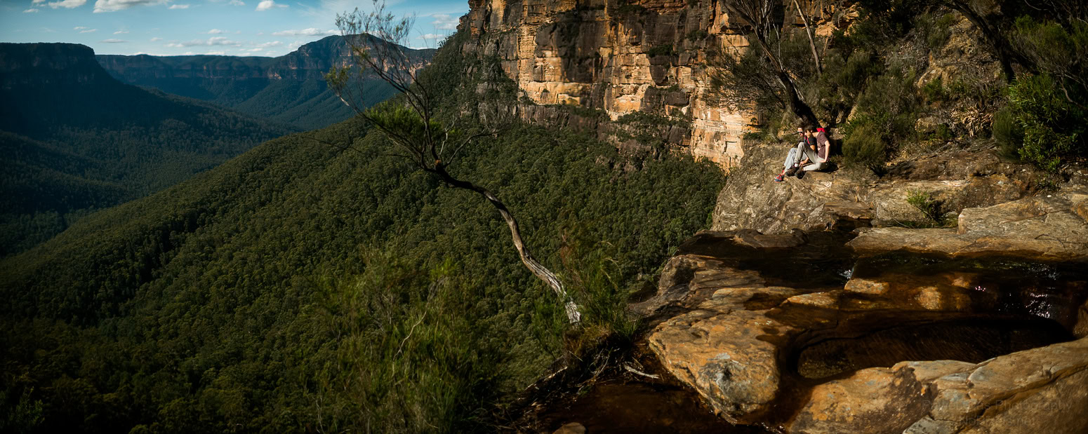
    Hi there, absolutely love these photos of yours on Fortress Creek Canyon Exit. I was hoping you could explain where this is and how to get down to Fortress Creek Canyon by walking? Thank you!

Leave a Reply

Your email address will not be published.