carrington falls bottom

carrington falls bottom


Info

walking distance: 7.9 km
duration: 5:17 h
walking: 2:45 h
elevation diff: 437 m
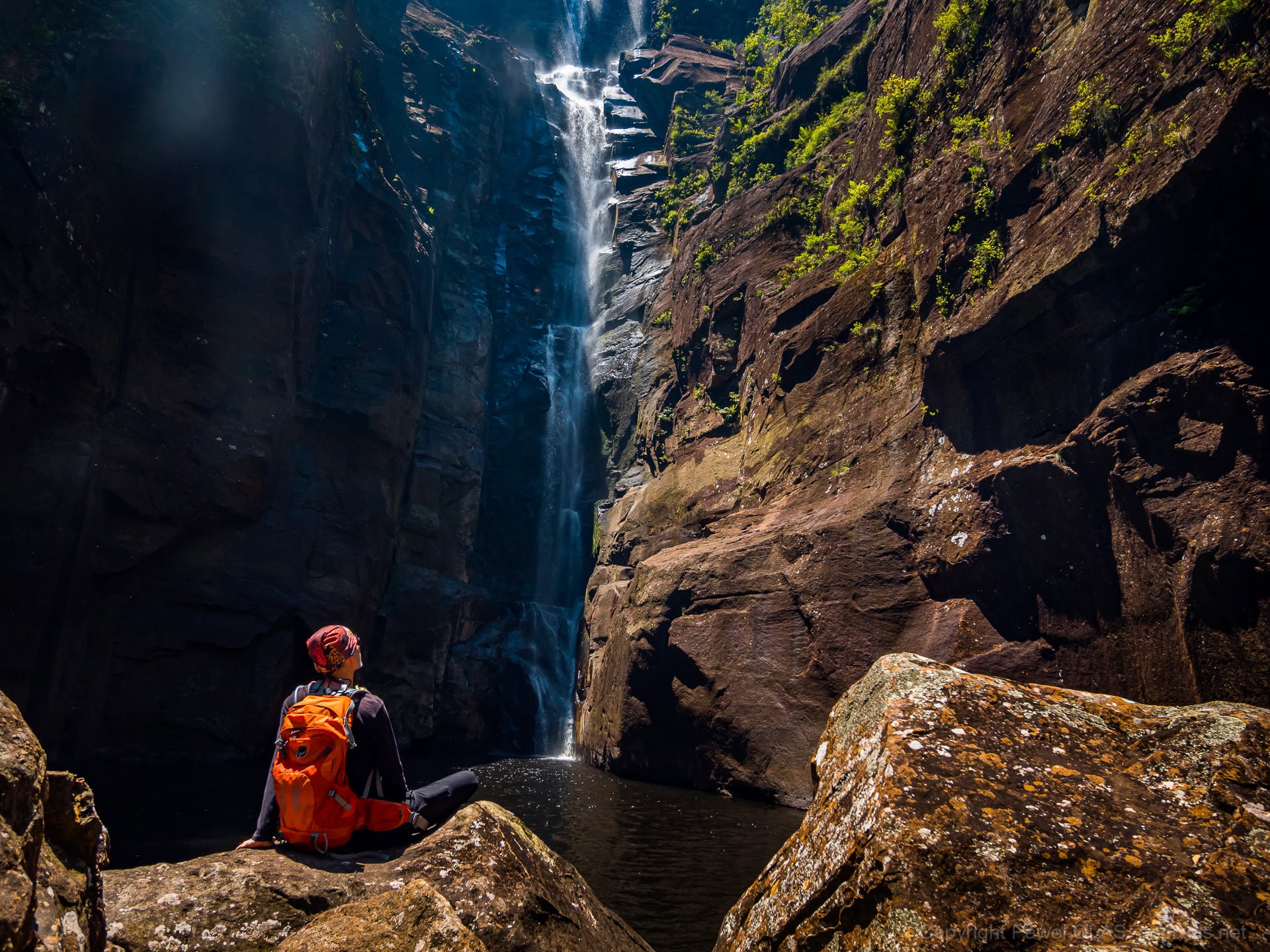
location: budderoo national park
driving distance: km
driving time: 2 h
water available: yes
parking: -34.6258,150.6557


gps tracks

Total distance: 8058 m
Max elevation: 569 m
Min elevation: 432 m
Total climbing: 444 m
Total time: 05:17:53
Download file: 19-11-04-carrington_falls_bottom.gpx

Video


Track notes

start at Izzards lookout


Alerts

Budderoo National Park

Other planned events: 1080 fox ground baiting program
NSW National Parks and Wildlife Service is conducting a continual and ongoing 1080 ground baiting program for the control of foxes from Friday 14 June 2024 to Friday 13 December 2024 to reduce the impacts on threatened species.
The operation will target foxes in the Carrington Falls, Budderoo Plateau, Knights Hill and Barren Grounds areas. Baits have been placed on NPWS estate and Crown road reserves with permissions.
The program is designed to minimise predator impacts on wildlife, especially threatened species.
1080 baiting signs are at all entries to the baiting location. Don’t touch baits or ejector devices. Some baits may be buried.
Domestic pets are not permitted in NSW National Parks managed lands. Pets and working dogs may be affected (1080 is lethal to cats and dogs). Pets and working dogs must be restrained or muzzled in the vicinity and must not enter the baiting location. In the event of accidental poisoning seek immediate veterinary assistance.
Penalties apply for non-compliance. For more information, contact the NPWS Fitzroy Falls office on 02 4887 8244 or send an email.

Closed areas: Access to the base of Gerringong Falls is prohibited
Access to the base of Gerringong Falls is prohibited.
The area around and down to the base of the Gerringong Falls has loose rocks, steep cliffs and unstable ground surface making it dangerous to access. The walk will remain permanently closed to the public to protect visitor safety.
Penalties apply for non-compliance. For more information, please contact the local Area at npws.illawarrahighlands@environment.nsw.gov.au or visit the NSW National Parks safety page for park safety guidelines.

Closed areas: Partial Closure to Lyrebird Loop
Minnamurra Rainforest Lyrebird Loop Walk has a partial closure due to flood damage. This closure affects the start of the Lyrebird Loop Walk, which restricts wheelchair access.
Penalties apply for non-compliance. For any further information, please contact the NPWS Minnamurra Rainforest Centre on 42 360 469

Closed areas: Minnamurra Rainforest Cafe closed
Minnamurra Rainforest Cafe is closed until further notice. Light refreshments and hot beverages are available for purchase from Minnamurra Rainforest Centre.
For further information contact Minnamurra Rainforest Centre on 02 4236 0469.

Other incidents: Minnamurra Rainforest may close at short notice
Minnamurra Rainforest is a popular location and will close at short notice if needed. This is to ensure visitation levels do not exceed safe capacity or due to the carpark reaching capacity. 
NPWS encourages you to plan your visit outside of peak periods of 11am to 2pm. 


Weather

.

7 Comments

  1. Greg McPherson

    This has just become my new favourite short walk! Your excellent video just adds to the appeal! It’s a wonderland down there.
    After exploring down the track, my kids and I returned and went down the Missingham Steps than traversed directly across and then up this track. It was fantastic!

    1. Pawel Olas

      Finding the “track” from the bottom is the tricky (and scary) part in this pretty rugged gorge. Such a tiny crack in hundreds of meters of the impassable cliff. Missingham Steps is on my list to do!

  2. Greg McPherson

    Missingham Steps is absolutely worthwhile. But they too can be really hard to find from the bottom. I’m getting a feel for it now.
    I expected my off piste Missingham to Izzard’s direct route to be arduous. It wasn’t at all. It was beautiful, tranquil and easy.

    1. Pawel Olas

      I’m itching to try it now :-) Thank you for the recommendation! I always thought that Missingham steps connected to Stevo’s track across the valley and that upstream hike from there was very difficult.

  3. Greg McPherson

    You’re entirely correct! Missingham does connect to and is in effect part of the Stevos loop track. I’ve done that track several times, and it too is a great walk. It’s also the best way to go. The upstream hike is indeed difficult and not recommended. I know this from experience.
    The walk I did recently is not a prescribed walk and there is no track of any nature. It shouldn’t be attempted without some accumulated knowledge.
    This traverses high above the river hugging the base of the cliff. It does not ascend the river. I could see no evidence of anyone having been there before and I’m not trying to advertise it.
    I’m guess I’m just saying that this area is awesome and has so many nocks and grannies to explore.

Leave a Reply

Your email address will not be published.