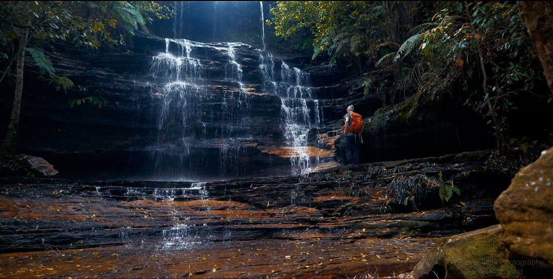
south lawson waterfall circuit

south lawson waterfall circuit


Info

walking distance: 4.6 km
duration: 2:30 h
walking: 1:34 h
elevation diff: 260 m
location: Blue Mountains
driving distance: 73 km
driving time: 1 h
water available: yes
parking: -33.7265,150.4375


gps tracks

Total distance: 4647 m
Max elevation: 710 m
Min elevation: 582 m
Total climbing: 248 m
Total time: 02:30:18
Download file: 22-11-01-south-lawson-waterfall-circuit.gpx

Video


Track notes


Photographs

PHOTO GALLERY

rHDPtgm
 
8NjkgRg
 
BdhWXNw
 
hnHCw3D
 
kDGJn4d
 
B6pz3qm
 
6NzSKvC
 
ZXv9Z4Q
 
.


Alerts

Blue Mountains National Park

Hazard reduction burns: RED HANDS CAVE BLUE MOUNTAINS NATIONAL PARK
There is a planned Hazard Reduction burn in this park from 26/03/2024. The fire is called RED HANDS CAVE BLUE MOUNTAINS NATIONAL PARK. Refer to the Rural Fire Service for latest information. Do not enter any closed area or area with fire. If you see an unattended fire call Triple Zero (000). Penalties apply for non-compliance. For more information about fire safety in parks and reserves, visit the NSW National Parks fire safety page for park safety guidelines.

Closed areas: Parts of Blue Mountains National Park closed
Many walking tracks, roads and fire trails within Blue Mountains National Park remain closed following sustained wet weather causing subsidence hazards, major landslides or infrastructure upgrades. 
The following areas are closed:
Katoomba and Leura

  • Honeymoon Bridge is closed due to rockfall risk
  • Federal Pass between Scenic World and Golden Stairs is closed due to a landslide.
  • Golden Stairs walking track will be closed Wednesday 3 to Friday 5 April and Wednesday 10 to Friday 12 April 2024 to allow for walking track upgrades.  Further closure dates to June 2024 to be advised.
  • Lone Lyrebird track is closed between Gordon Road and the War Memorial, due to subsidence. Detour is in place.
  • Prince Henry Cliff walk is closed between Gordon Falls picnic area and Elysian Rock lookout, due to a landslide. Visit the Blue Mountains City Council website for information.
  • Mt Solitary eastern access is effected by Kedumba Valley Road closures below.
  • Part of Lindeman Pass is closed due to a major landslide below Gladstone lookout. Roberts Pass is closed due to rockfall and landslide hazards.   
  • The Six Foot Track will be closed from Katoomba (Explorer's Tree) to Alum Creek, from 8 April to 12 April 2024 for Local Land Services to undertake aerial pest management.
Wentworth Falls and Woodford 
  • Valley of the Waters track is closed below Sylvia Falls. There is no access to Roberts Pass, Vera Falls, Hippocrene Falls or Wentworth Falls from Valley of the Waters.
  • Charles Darwin walk (part of the Grand Cliff Top walk) is closed between Fletcher Street and Weeping Rock. Detours are in place to provide directions to Wentworth Falls Picnic Area. Visit the Blue Mountains City Council website for information.
  • Part of National Pass (west of Wentworth Falls middle crossing) is closed due to major landslide. 
  • Wentworth Pass and Slack Stairs are closed due to landslide.
  • Kedumba Valley Road and campground will be closed until late April 2024 for road repairs.  Open to pedestrians over Easter Long weekend and weekends.  
  • Ingar Road is closed where it traverses private property at the western end. You can walk into Ingar campground via Andersons or Bedford Roads. 
Blackheath, Mount Victoria and Bells Line of Road
  • Govetts Creek access routes including Horse track and Rodriguez Pass (Bridal Veil Falls) are closed due to rockfalls and landslides. Entry is not permitted due to serious risk of injury or death. Entry is not permitted into the Grose Valley from Govetts Leap, Evans lookout, Grand Canyon track, or south of Acacia Flat.
  • Pulpit Rock Reserve, lookouts and walking track are closed. Visit the Blue Mountains City Council website for information. Pulpit Rock walking track from Popes Glen is open as far as the NPWS boundary (as shown on Google maps).
Canyons and rock climbing
  • Climbing and canyoning areas in the Blue Mountains are open unless the access road or track is closed, or the site is listed in this alert.  
  • Malaita Point and Wall abseil routes are open, exit through Scenic World to Furber Stairs (no exit via Golden Stairs due to a landslide).
Penalties apply for non-compliance. For more information, please contact the local office.

Closed areas: Glenbrook precinct - partial closures due to hazard reduction
Please note precinct closures due to the Red Hands Cave hazard reduction burn:
  • Red Hands Cave will be closed until Friday 5 April;
  • Red Hands Cave walking track (aka Campfire Creek track and Loop track) will be closed until Friday 5 April;
  • The Singles Track cycleway is partially open: The front section from Glenbrook entry to Euroka turnoff is now open. The back section from Euroka turnoff to Red Hands Cave is currently closed until Friday 5 April.
  • Woodford Oaks trail will remain closed to all vehicles until further notice.
  • Woodford Oaks trail will reopen late Thursday 28 March to cyclists only. 
 
The following areas are now open:
Euroka campground, Mt Portal Lookout, Tunnel View Lookout, Jellybean Pool, Blue Pool and Glenbrook Gorge walking track.
 
Penalties apply for non-compliance. For more information, contact the local NPWS office on 02 4720 6200.

Hazard reduction burns: Western Ridge HR
There is a fire in this park called Western Ridge HR. Refer to the Rural Fire Service for latest information. Do not enter any closed area or area with fire. If you see an unattended fire call Triple Zero (000). Penalties apply for non-compliance. For more information about fire safety in parks and reserves, visit the NSW National Parks fire safety page for park safety guidelines.

Hazard reduction burns: Red Hand Cave HR
There is a planned Hazard Reduction burn in this park from 04/03/2023. The fire is called Red Hand Cave HR. Refer to the Rural Fire Service for latest information. Do not enter any closed area or area with fire. If you see an unattended fire call Triple Zero (000). Penalties apply for non-compliance. For more information about fire safety in parks and reserves, visit the NSW National Parks fire safety page for park safety guidelines.

Closed areas: Waratah Native Gardens picnic area closed
Waratah Native Gardens picnic area is closed until further notice. This includes Gorge walking track. No access to the area is permitted. 
Penalties apply for non-compliance. For more information, please contact the NPWS Hawkesbury-Nattai area office on 02 4720-6200

Safety alerts: Remote walking track conditions
Remote routes within the Kanangra Wilderness Area including Kanangra to Katoomba (K2K) trail have been impacted by heavy fire regrowth and flood damage.
In some places, tracks are no longer visible and are not easy to navigate, taking longer to traverse than expected. Limited to zero water sources are currently available along routes.
If you plan to walk in the area, please ensure you have an appropriate level of experience, navigation skills and equipment including Personal Locator Beacon (PLB). 
Mobile reception is limited so alternative communication methods are strongly recommended.
For more information, contact the NPWS Blue Mountains Heritage Centre on 02 4787 8877.

Closed areas: Closed areas due to roadworks
Murphys Glen and Ingar campgrounds will be closed on Monday 26 February 2024 and from Monday 4 March to Friday 22 March 2024 for road repairs. The following areas will also be closed during this period:
  • Bedford Road and Murphys Roads
  • Bedford Creek trail
  • Andersons mountain bike exit to Woodford 
Walkers and cyclists are permitted past locked gates on weekends. For more information, contact the local NPWS office.

Closed areas: Kedumba River campground and Kedumba Pass
Kedumba River campground and Kedumba Valley Road on Kedumba Pass will be closed until the end of April 2024.
This closure is due to major road maintenance on Kedumba Valley Road (Kedumba Pass). For further information, contact the NPWS Blue Mountains Heritage Centre on 02 4787 8877.

Closed areas: Red Hands Cave walking track - Partial opening
Red Hands Cave walking track (also known as Campfire Creek walking track) is undergoing a partial closure until May 2024, for extensive flood damage repairs.
Repairs are underway for the lower section between Link track and Red Hands Cave through the gully. This pathway will be closed until May 2024. 
The rest of Link track and Red Hands Cave/Campfire Creek walking track is open, with access now available all the way from Red Hands Cave through to the causeway.
Red Hands Cave remains open to the public during this time, with vehicle access via the roadway and carpark.
Penalties apply for non-compliance. For more information, contact the local NPWS office.

Closed areas: Six Foot track - Bowtells Bridge closure
Bowtells swing bridge on Six Foot track is closed to protect public safety. An upgrade is being planned and the bridge is expected to reopen in May 2024. Signs and barriers are in place to prevent access onto the bridge.
Crown Lands, which manages the bridge, is advising track users not to attempt to cross Coxs River. Any attempts to cross the river are at your own risk and are discouraged due to the potential for slips or falls, rainfall and risk of flash flooding.
For further information visit the Six Foot track website.

Other planned events: Notice of ongoing 1080 baiting program
NSW National Parks and Wildlife Service (NPWS) is conducting ongoing ground baiting program from Thursday 2 November 2023 to Wednesday 1 May 2024 in the following areas:
  • Abercrombie River National Park
  • Abercrombie River State Conservation Area
  • Kanangra-Boyd National Park
  • Blue Mountains National Park (southern section)
  • Wollemi National Park (Wolgan Valley area)
  • Gardens of Stone National Park
  • Jenolan Karst Conservation Area
  • Turon National Park
  • Marrangaroo National Park
The operation will use 1080 (sodium fluoroacetate) poison for the control of wild dogs and foxes.
The program is designed to minimise predator impacts on wildlife, especially threatened species, and to minimise impact of wild dogs on neighbouring stock.
Signs will be placed at the entry to the baiting location. Domestic pets are not permitted in NSW National Parks managed lands. Pets and working dogs may be affected (1080 is lethal to cats and dogs). Pets and working dogs must be restrained or muzzled in the vicinity and must not enter the baiting location. In the event of accidental poisoning seek immediate veterinary assistance.
For more information, contact the NPWS Kanangra area office at Oberon on 02 6336 6200.


Weather

.

Leave a Reply

Your email address will not be published.