canoe creek

canoe creek


Info

walking distance: 3.7 km
duration: 4:02 h
walking: 3:38 h
elevation diff: 411 m
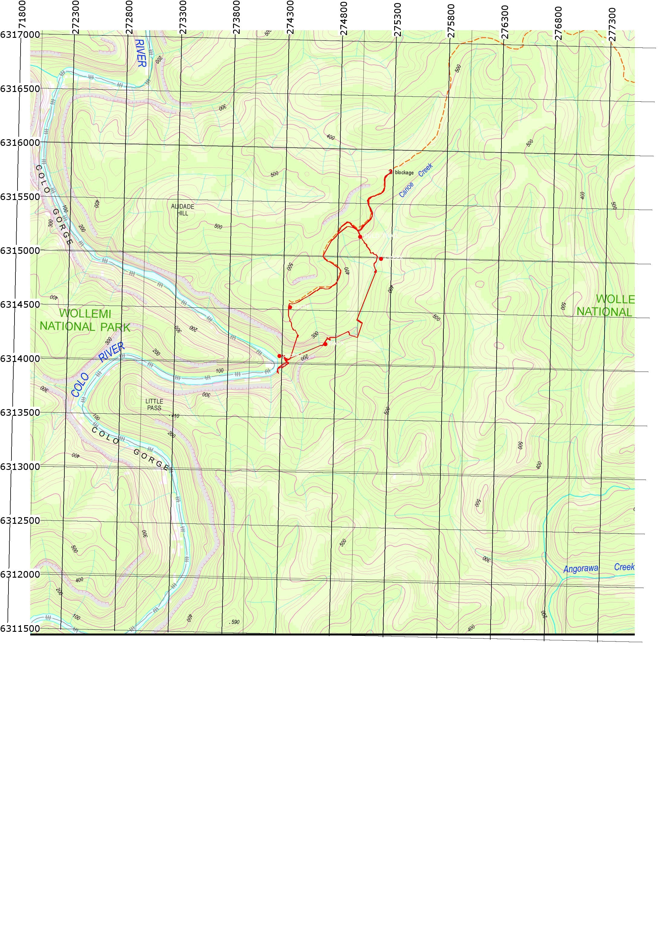
location: wollemi
driving distance: 90 km
driving time: 1:20 h
water available: plenty
parking: -33.2735,150.5872
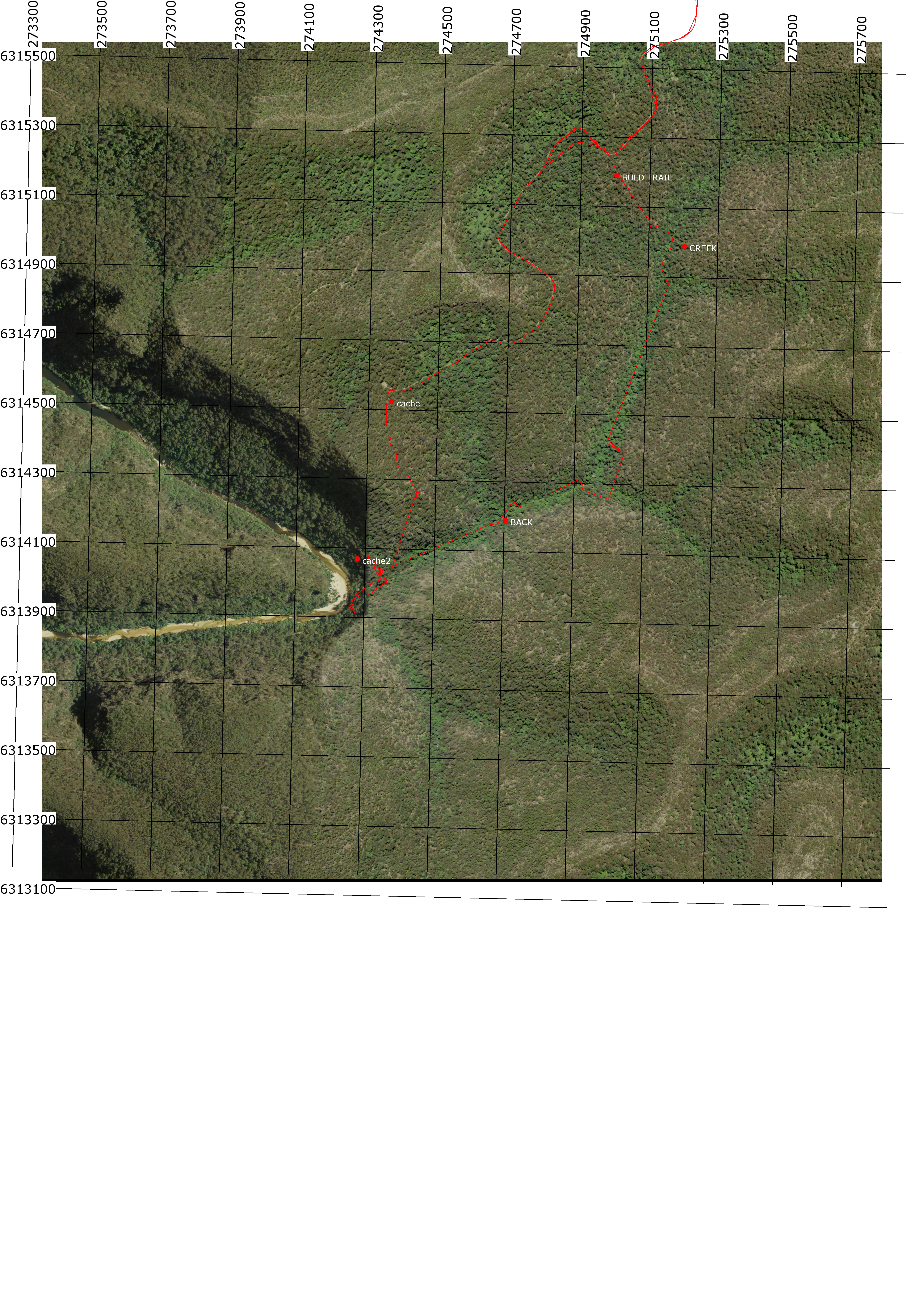

gps tracks

Total distance: 3897 m
Max elevation: 453 m
Min elevation: 108 m
Total climbing: 243 m
Total time: 04:02:53
Download file: canoe_creek_walk_down.gpx
Total distance: 3417 m
Max elevation: 451 m
Min elevation: 86 m
Total climbing: 483 m
Total time: 02:51:51
Download file: canoe_creek_walk_up.gpx

Video


Track notes


second one day hike with 7yo

Total distance: 6881 m
Max elevation: 506 m
Min elevation: 92 m
Total climbing: 493 m
Total time: 08:36:26
Download file: 16-04-01-canoe_creek_with_hanya2.gpx

printable topo map

printable satellite map


11-11-01(0)

11-11-01(0)-4

11-11-01(0)-6

11-11-01(00930)

11-11-01(00961)


Alerts

Wollemi National Park

Safety alerts: Bob Turners track - 4WD access only due to damaged road
Bob Turners track in Wollemi NP is currently 4WD access only - not suitable for 2WD vehicles due to recently damaged roads.
Works will be arranged shortly to repair the track.
For more information, contact the local park office on (02) 4720 6200.

Other planned events: Notice of ongoing 1080 baiting program
NSW National Parks and Wildlife Service (NPWS) is conducting ongoing ground baiting program from Thursday 2 May 2024 to Friday 1 November 2024 in the following areas:

  • Abercrombie River National Park
  • Abercrombie River State Conservation Area
  • Kanangra-Boyd National Park
  • Blue Mountains National Park (southern section)
  • Wollemi National Park (Wolga
  • Gardens of Stone National Park
  • Jenolan Karst Conservation Area
  • Turon National Park
  • Marrangaroo National Park
The operation will use 1080 (sodium fluoroacetate) poison for the control of wild dogs and foxes.
The program is designed to minimise predator impacts on wildlife, especially threatened species, and to minimise impact of wild dogs on neighbouring stock.
Signs will be placed at the entry to the baiting location. Domestic pets are not permitted in NSW National Parks managed lands. Pets and working dogs may be affected (1080 is lethal to cats and dogs). Pets and working dogs must be restrained or muzzled in the vicinity and must not enter the baiting location. In the event of accidental poisoning seek immediate veterinary assistance.
For more information, contact the NPWS Kanangra area office at Oberon on 02 6336 6200.

Closed areas: Wheeny Creek campground closed due to flood damage
Wheeny Creek campground will be closed from Wednesday 3 April 2024 until Sunday 25 May 2024, due to impacts from flooding and storm damage.
For more information, contact the local park office on (02) 4720 6200.

Closed areas: Part of Wollemi National Park, around the Nullo East trail is closed for ground pest control operations between the 6th and 10th of May 2024
A ground pest control program will be undertaken in Wollemi National Park around the Nullo East trail between 5am on the 6th of May, until 5pm on the 10th of May 2024. The Nullo East trail is closed to public access during this period.  Penalties apply for non-compliance. For more information, contact the NPWS Mudgee Office at (02) 6370 9000

Closed areas: Glow Worm Tunnel closure
The Glow Worm Tunnel visitor precinct and associated walking tracks are currently closed for upgrade works, and will re-open Saturday 1 June.
This closure includes:
  • Glow Worm Tunnel carpark
  • Glow Worm Tunnel walking track
  • Pagoda track (Old Coach track)
  • Glow Worm Tunnel to Newnes walking track (to ‘four-ways’ intersection).
  • Dry Canyon access track (Wolgan View canyon).
There is no access to Glow Worm Tunnel during this time.
Penalties apply for non-compliance. For more information, contact the local NPWS office on 02 6336 6200.

Closed areas: Newnes Campground Pedestrian Access Only
Newnes campground is available for walk-in access only. The campground is remote and can only be accessed by long walks via the Old Coach Road or the Pipeline Track.
Campers need to be fully self-sufficient and carry all supplies including drinking water. Campers are strongly advised to complete a trip intention form for their safety. Pack it in, pack it out – please take all rubbish with you when you leave.
 
There is no road access due to the Wolgan Road collapse and continuing land slip risk at Wolgan Gap. Wolgan Road is managed by Lithgow Council.
 
Penalties apply for non-compliance. For more information, contact the local NPWS office on 02 6336 6200

Closed areas: Glow Worm Tunnel Road and Camp Road roadside vegetation management
NPWS will be implementing roadside vegetation management during April and May 2024 in the Gardens of Stone State Conservation Area and Wollemi National Park.
Roads affected are:
• Camp Road between Eastern Boundary Road and Forest Camp:
o Closed to the public for approximately 1 week.
o Access to Forest Camp via Eastern Boundary Road
• Glowworm Tunnel Road from Bungleboori Day Use Area to Galah Mountain Road:
o Traffic control will be in place for approximately 3 to 4 weeks. One-way traffic only. Expect short delays.
Please use caution when driving and obey all signs and directions.
Penalties apply for non-compliance. For more information, contact the NPWS Kanangra office on 6336 6200.

Other planned events: Ganguddy Dunns Swamp - construction works occurring
Construction works occurring in the day use area from 29 April 2024 until the 20 May 2024 between the hours of 0700hrs to 1600hrs.  Earthmoving equipment operating in the area. Please adhere to safety signage.

Closed areas: Roads closed due to flood damage
The following roads in this park are closed due to storm and flood damage:
  • California trail - closed until late June 2024
  • Martindale trail - closed until June 2024
Visitor areas that are currently closed include:
  • California Hut - closed until late June 2024
Gates have been locked, and signs are in place on closed roads. Expected reopening times are subject to weather delays.
Penalties apply for non-compliance. For more information, contact the NPWS Bulga area office.

Closed areas: Wheeny Creek campground - Boobook section closed
The Boobook campground and picnic area within Wheeny Creek campground has permanently closed due to flood damage. Please note that the rest of Wheeny Creek precinct remains open for bookings.  Penalties apply for non-compliance. For more information, contact the local NPWS office on 4720-6200.

Wollemi Flora Reserve

Closed areas: Roads closed due to flood damage
The following roads in this park are closed due to storm and flood damage:

  • California trail - closed until late June 2024
  • Martindale trail - closed until June 2024
Visitor areas that are currently closed include:
  • California Hut - closed until late June 2024
Gates have been locked, and signs are in place on closed roads. Expected reopening times are subject to weather delays.
Penalties apply for non-compliance. For more information, contact the NPWS Bulga area office.


Weather

.

Leave a Reply

Your email address will not be published.