Info
walking distance: kmduration: ? h
walking: 0:00 h
elevation diff: m
location: Thirlmere Lakes National Park
driving distance: 100 km
driving time: 1:30 h
water available: yes
parking:

Video
Track notes
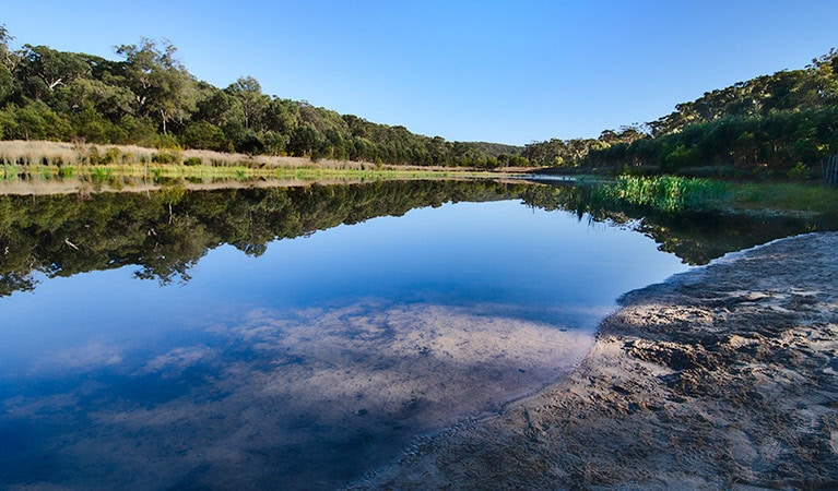
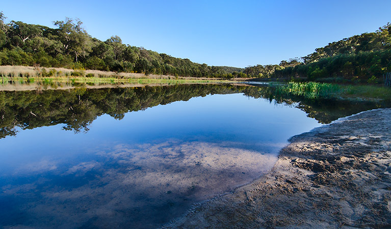
nice lakes for canoeing with a 6km walk around. near picton.
http://www.nationalparks.nsw.gov.au/visit-a-park/parks/Thirlmere-Lakes-National-Park
A Hidden Valley: As you drive down the Hume Highway towards Mittagong, south of the Picton Road you pass through a rather bland patch of low forest in a slightly rising landscape. Geologists call this the Nepean Ramp, after the Nepean River which flows down it; the early European settlers called it the Bargo Brush, after the thick scrub.
But out of sight away to the west lies quite another, more spectacular landscape: the Burragorang Valley. This is one of those curious places on the city’s outskirts which were much better known to Sydneysiders of times past than they are now. In the case of the Burragorang Valley, the reason for this is the Warragamba Dam which, built between 1948 and 1960, inundated much of it.
The Burragorang was settled by the 1830s, and remained a pastoral and mining enclave right down until it was flooded. To get a feel for what it was like, see the 1879 painting ‘Burragorang Valley near Picton’ by JH Carse in the Art Gallery of New South Wales. The valley was often painted and the comparison between Carse’s colonial Arcadia and the vibrant 1946 ‘Burragorang Landscape’ by Sydney’s very own Vorticist Weaver Hawkins (Plate 18 in ‘The Art and Life of Weaver Hawkins’ by Eileen Chanin and Steven Miller) shows just how much artistic vision in Sydney changed in the intervening 67 years.

Thirlmere Lakes and the Couridjah Corridor: The Sydney Catchment Authority (SCA) restricts access to the area surrounding Lake Burragorang to protect the quality of the city’s drinking water, notwithstanding the fact that fish fornicate in it all the time. Nevertheless the walk down the Couridjah Corridor, along the banks of Blue Gum Creek, takes you through the Nattai Wilderness right up to the boundary of the exclusion zone, the Warragamba Special Area, itself.
To get to the starting point of the walk, drive to the small town of Thirlmere, which is reached through Picton then via the Thirlmere Way. Cross the railway line and turn left into Barbour Road, leaving the NSW Rail Transport Museum on your left. After 2.4 kilometres you will see Slades Road – signposted ‘Thirlmere Lakes National Park’ – turning off to the right. Drive down to the bottom of the hill, then bear left and continue on the road for 7.7 kilometers until you reach the Bluegum Carpark. Park here – there’s a locked gate just down the track. (Caution: for the last four kilometers the unsealed road surface can be fairly ‘challenging’, with ruts, deep holes full of water, etc. Leave the Maserati at home.)
But before you reach the carpark you will have driven past the Thirlmere Lakes themselves, one of the Sydney Region’s geological marvels. This is a system of five interconnected lakes, according to one theory the headwaters of an ancient river, and so old (fifteen million years) that some of its life forms, including the freshwater sponge Radiospongilla sceptroides, have evolved distinct forms. Water levels in the lakes go up and down considerably and there is concern that nearby coal mines are draining them; but a recent inquiry determined that there was no evidence that this was the case. Whoever is right, the picnic grounds make a good place to stop on the way back from your walk.
The walk starts amidst a stand of Blue Gum, and the Sydney region offers few finer sights than this. With their smooth white trunks soaring like giant candles above the understory, a Blue Gum Forest evokes awe. It’s appropriate that pioneer bushwalker Myles Dunphy’s 1931 campaign to preserve the Blue Gum Forest, as the superb stand in the Grose Valley below Blackheath is called, marks the beginning of Sydney’s modern conservation movement.
The walk continues along the road besides the banks of Blue Gum Creek. After a while the Blue Gum gives way to other trees, but if you keep your ears open you may hear a lyrebird.
Useless Bit of Information: It’s amazing that the first recorded sighting by Europeans of a lyrebird came only in 1798, a full ten years after the initial settlement at Sydney Cove. It’s amazing that it took so long, because even after two centuries of dodging the feral cats, lyrebirds are still common in the Sydney hinterland. You can scarcely venture into the Blue Mountains bush without hearing one and they are found, for example, in the Garigal National Park, just twenty kilometres from the CBD.
The formal recognition of the lyrebird came from a specimen collected here in the Bargo Brush on an expedition led by the remarkable John Wilson, whose career as an explorer is described by Chris Cunningham in his 1996 ‘The Blue Mountains Rediscovered’. Wilson was a convict, transported on the First Fleet, who as soon as his sentence expired in 1792 took to the bush, joining aboriginal society and roaming all over Sydney’s hinterland.
By January 1798 the penal colony of Sydney was plagued by desertion as convicts walked off into the bush in search of an easy life in China, widely believed to be just over the Blue Mountains. The problem was so acute that Governor Hunter commissioned Wilson to lead a party, including convicts, into the hinterland to prove that this was not so. It was on this expedition, which reached well into the Southern Highlands, that a specimen of the lyrebird was collected. It caused ‘a sensation’ (Cunningham) when it was taken back to Sydney.

Pondering the fate of Wilson (which you’ll have to read Cunningham to discover), the walker continues down the road. On the other side of Blue Gum Creek the dramatic walls of Mount Rice, and then Perrott Bluff, rise above the forest. After about 8 kilometers the road, by now dipping up and down considerably, reaches a concrete ford across the Little River – this is as far as you can go. After a lunch break spent absorbing the tranquility, retrace your steps – and don’t forget to stop at the picnic area on the shores of Lake Couridjah on the way home.
Distance: about 16 kilometres.
Difficulty: Not difficult. Though quite a long walk, it is all on a formed road. As you approach Little River there are a few steep slopes but it would be wrong to describe this as anything except easy.
Maps, websites:
http://www.environment.nsw.gov.au/NationalParks/parkHome.aspx?id=N0033
Alerts
Thirlmere Lakes National Park
Safety alerts: Thirlmere Lakes National Park - damage to roads from recent heavy rain
The roads in Thirlmere Lakes National Park have been damaged by recent heavy rains. Park visitors are advised to take extra care when driving on roads in the park.
In particular, Pumphouse Road has sustained surface damage, so visitors are advised to enter the park through Slades Road where possible.
Due to the rise in lake levels, sections of the walking track are likely to be underwater and may not be passable.
Remember, it’s never safe to drive, ride or walk through flood waters. Check Live Traffic NSW for up-to-date information about road closures.
For assistance during severe weather visit the NSW SES website. In life-threatening situations call emergency services on Triple Zero (000).