
Info
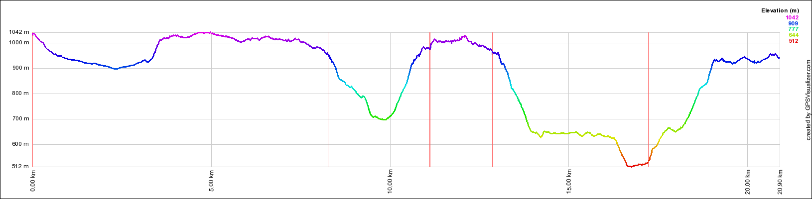
walking distance: 13.3 kmduration: 0:00 h
walking: 0:00 h
elevation diff: 400 m
location: wollemi National Park
driving distance: 148 km
driving time: 2:50 h
water available: only at the beginning
parking: -33.2314,150.0762

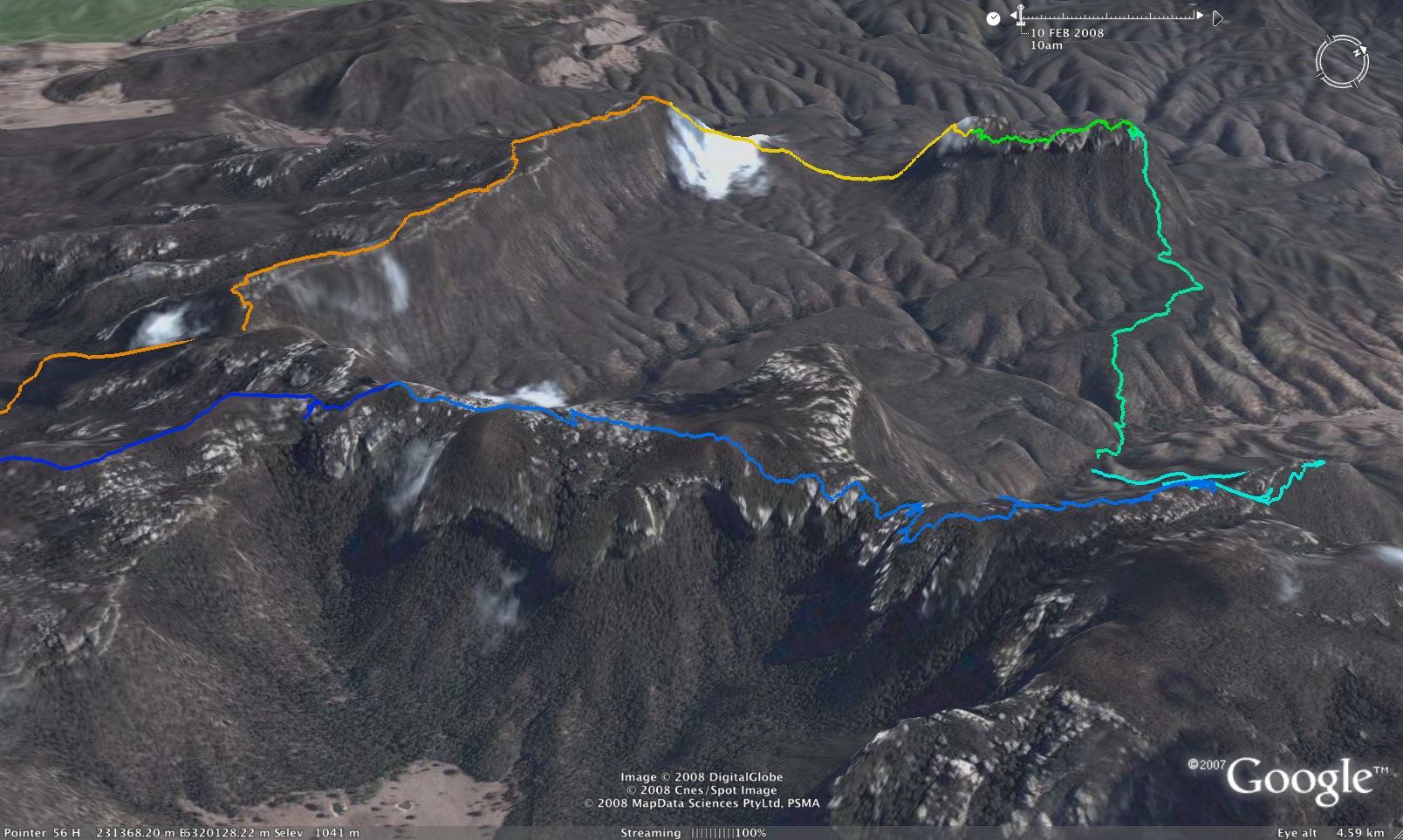
gps tracks
Max elevation: 0 m
Min elevation: 0 m
Total climbing: 0 m
Video
Track notes

DRIVING MAY BE A BIT TRICKY
We started out coming in from Ben Bullen in a subaru forester, but baulked at the top of a very roughly cut up descent about 6KM from the gap. Continuing past that point would need a real high clearance 4WD, not an AWD I think.
We then drove around Angus Place, and took the road that goes along the Coxs River, parking at the top of the hill where the road forks down to Baal Bone Gap and right to Cape Horne. Just below that point the road gets really bad (per the youtube link above) and even a real 4WD will have some challenges, although I have previously seen 4WDs descend that spot in convoy with winches.
So my take on current situation:
in low clearance vehicle it’s going to be a long walk
in a high clearance AWD, best bet is via Angus Place, and park 3KM from Baal Bone gap.
in a 4WD, you should be able to drive all the way from Ben Bullen to Baal Bone Gap
baal bone point:
WATER:
The only reliable water is at Baal Bone Gap – from the pressure reducing station. No water from there to Baal Bone Point (except from rock pools on the pagodas just after rain), then no water from there to Pantoneys Crown – since you walk across a saddle. I usually carry water up onto the Crown, sufficient for the night and next morning. But on many trips – I do find rock pools on top. There is (probably) permanent water on the top in pools in a small canyon – but this is a bit out of the way to get to.
You can get water from the main creek below the Crown – near the road that goes down from the Gap. But not always. These creeks seem to dry up very quickly and also they do flow through a limestone area (The Blue Rocks) – and the water flows underground.
some track notes (july)
After picking up Gill and Alexa from Alexa’s place in Wollstonecraft, we headed up via a coffee stop at Maccas at Richmond (for the girls) and a pie stop at the NRB (North Richmond Bakery) – for everyone. Heading out along the Wolgan Rd, we turned off on the Long Swamp Trail. I was expecting some large puddles almost immediately but the road appeared to have been recently maintained, and it was several kilometres before we had to stop. The first slushy section looked pretty dodgy, and I had to take the Camry cross country to avoid it. The next was manageable, and the third had a long pool but seemed shallow with a solid bottom. Appearances can be deceiving. Just as I was driving out of the last puddle, the car slewed to the right and sank. The puddle had a soft edge, which we hadn’t managed to find, and we were well and truly bogged. The front of the car was sitting on the sand, so we weren’t going forwards or backwards. Alexa was the first to brave the icy water, and confirmed we were in a bit of trouble. There was nothing for it but to empty out the car, pull out the jack, and start trying to free it.
I jumped in the water, and lasted only about fifteen seconds before I couldn’t stand the pain. Luckily my feet went numb pretty quickly, so I could no longer feel anything. Some large flat chunks of log had been conveniently left on the bank, and we used these to get a firm surface for the jack. It was slow going, but we got a reasonable pile of branches under the wheel, and decided to give it a go. Gill drove and I pushed and we got traction until … the car slid off the side of the branches and back into the ditch.
It had still retained some of the height we had gained using the jack, so we weren’t back to square one. But we were rapidly running out of room next to the bank. I managed to bend the jack fitting having to work the lever at an acute angle, and there was a time when I was struggling to even get it to turn. This time we filled the entire slushy edge with branches so that the car couldn’t slide off. Fingers crossed, we tried again, and … success! Typically, just as we were loading the packs back in, a 4WD rolled up and asked if we needed any help. It could have arrived an hour and a half earlier!
By this stage it was 10:45am and things were starting to look a bit dicey in terms of time. I said we would go another 15 minutes and see how far we got. There were a couple more bits of road that had caused us problems last time, and if we got stuck at either of them, we would probably not make Pantoneys by dark. Thankfully the road had been fixed, and, other than a couple of easy wet bits, we made it to the top of the steep hill without any further stops.
Packs on, we set off down the lovely cliff lined gully towards Baal Bone Gap at a brisk pace. We didn’t have too much difficulty getting up on to the tops, and were greeted immediately by a massive boot shaped rock outcrop I had seen before. A few photos later we set off along the cliff edge, with excellent views across the Crown Creek valley and the cliffs of the Red Rocks in the distance.
The cliff views stopped for a while as we headed into the forest. Gill rolled her ankle on a rock, but pressed on, despite obvious pain. We made our way out to the start of the finger ridge that points towards Pantoneys Crown and stopped for lunch while Gill strapped her ankle up.
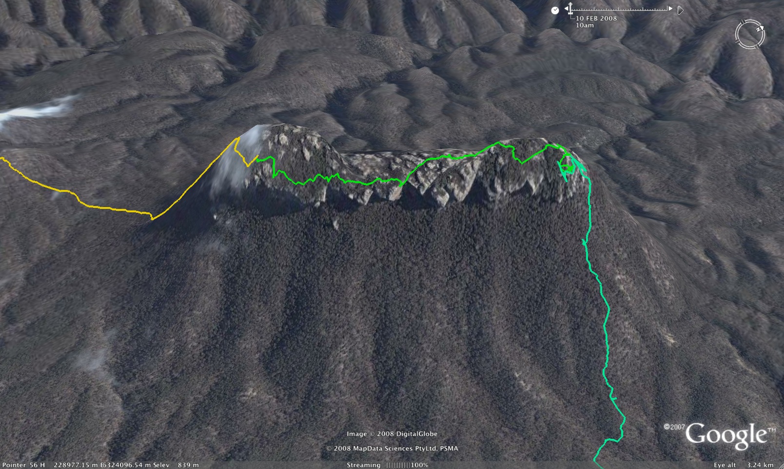
After lunch we headed out to the end of the finger ridge, over numerous spectacular pagodas and rocky outcrops. The most spectacular of all must be the massive detached block right at the end of the ridge. I wonder if it has been climbed? Finding and descending the pass at the end was not too difficult, and we followed a track down the ridge for some distance before the ridge itself petered out. It was a steep climb up the other side, and it was well after 4pm before we got to the top. I thought I had a reasonable memory of where the pass was, but the most obvious gully seemed far too close to the nose from where I remembered it, as well as a bit steep at the bottom. So around we went looking at gullies until the slopes got steeper and it became pretty obvious that the obvious earlier gully was it.
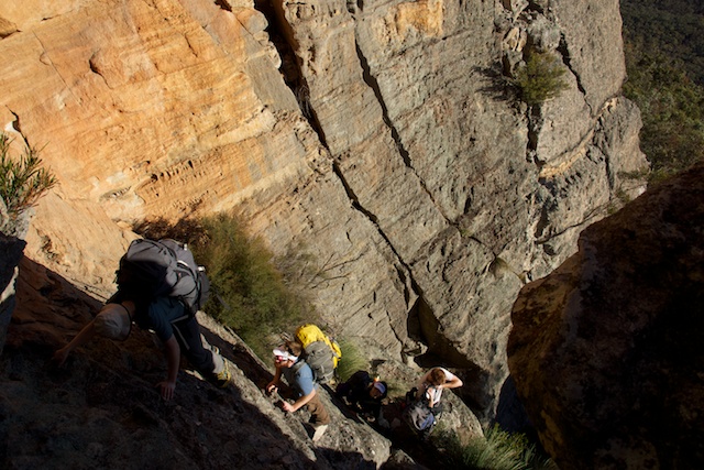
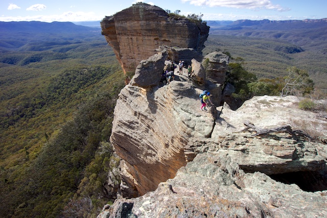
This had wasted some time, and it was now after 4:30pm. Given it was getting dark around 5pm, time was starting to get very tight. I raced up the bottom section and started hauling packs up. There is very little space to leave packs on the intervening ledges, and the risk of knocking loose rocks off is quite high. On the very exposed section we pulled out the rope and used it to get the packs up. By this stage a chill wind had picked up, blowing straight up the gully, and my hands had gone just about numb. Not a good sign as we were only half way up. Thankfully by this point we could see the top, and the last few pitches are much less exposed. Still, by the time I hauled the last pack up to the very top, I couldn’t feel a thing, and I could barely lift the last pack over the edge for Rachel to move on. Gill and Alexa scrambled up from the chimney where they had been passing the packs and we huddled behind a rocky outcrop out of the wind. By this stage it was getting dark, so we set off across the tops to what I hoped was a lovely sheltered campsite amongst pagodas. The campsite was pretty good, although a little breezy for a while until the wind died down after dark. We settled down to cheese and crackers, port, soup, dinner, custard and brownies, more port and finally hot chocolate around a pleasant fire.
I awoke before dawn and watched the sun rise while taking photos of the cliffs and valleys. After dwawdling our way along the top of Pantoneys we reached the cairn and spent some more time taking photos and checking the entries in the log book. The most recent was from September 2006 – 10 months ago! I assume people don’t know where to find it.
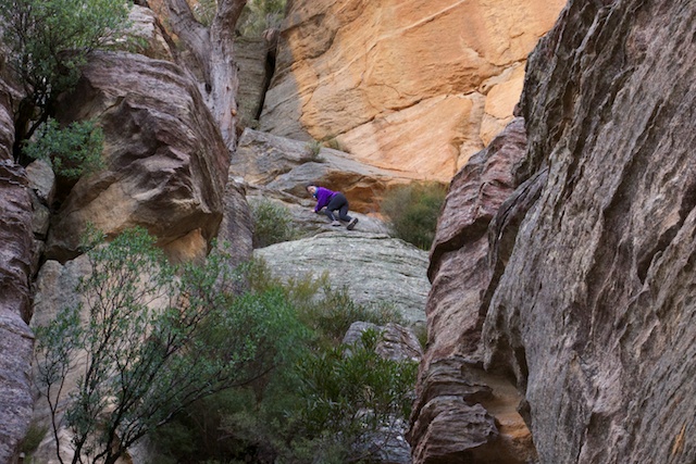
Further along the Crown we ended up on the wrong side of the pagodas and descended a gully where we had to fight vegetation to climb back out on the other side. A bit of wasted effort. From here it was easy going to the cliff edge where we started looking for the pass down. It didn’t take us long to find, a crack leading to a hidden tunnel and thence into another slot. We were soon down and looking for the route down to the next level. This turned out to be a bit harder to find, mainly due to a small tree having fallen on top of the chimney. I pushed it over the cliff with some effort and we lowered packs and climbed down the slightly tricky chimney. There was one more episode of pack passing with an easy scramble, and then we were sliding our way down scree slopes.
From there we headed on a bearing down the skirt of the Crown. Last time we had ended up on the wrong ridge and I was hoping this time to get the navigation right. Down on a flat section we checked the map and GPS and we were looking pretty good. So while it seemed like a good idea at the time, it was probably a mistake dropping into the creek that was on our bearing. Looking at the map and GPS plot the next day, the creek did a dog leg depositing us a ridge over from where we wanted to be, not that we knew it at the time. Our next creek and ridge were both heading in the wrong direction, but by this stage it was hardly worth backtracking. Instead we followed a creek downstream without too much difficulty, ending up in private property.
From there we headed up the fire trail into the National Park. We were passed by a couple of car loads of hoons while we were eating lunch and I expected to see them back again pretty quickly once they reached the locked gate. I was quite surprised to find them rockclimbing and abseiling at a crag a little way up the road. We kept up a solid pace all the way back to the car as we still needed to get the car back out along the fire trail. That proved to be easier said than done. At the final slushy puddle, the traffic while we had been in the bush had made a mess of the road, and we were unlikely to get through without getting bogged. Instead, we went cross country again, and built up the boggy bits that we would still have to cross. Despite a few wheel spins, some pushing from the girls got us off the one point where we got stuck and we were soon back out at the main road, somewhat relieved.
We headed back to Richmond for dinner, an excellent weekend walk.
———————————————————————————————————————————————————-
another trip report (winter)
We all met at the service station at the start of Wolgan Road (cnr Castlereagh Highway) on Saturday morning at around 11:00am. We left one of the cars in Lidsdale and then travelled along the dirt track beside the upper Cox’s. We parked before the big drop on the trail and set off. Along the way past Baal Bone Gap camp area we eventually climbed up on the fire trail before leaving it and having lunch on a pagoda with a view of the colliery and Baal Bone Gap. There were other walkers on the ridge to the East heading toward Baal Bone Point. On the way we noticed a few small “dishes” of water atop pagodas. We had gotten going late and found ourselves at Baal Bone Point at around 3:30pm. A decision was made to stop there to enjoy the sunset rather than to continue across the saddle to the lower end of Pantoney’s Crown. Some of the group went looking for water and others made the fire. We backtracked to manage to syphon some liquid from a dish which was located in a most improbable location. The result was some clean but yellowish water and some of the dregs that resembled “texas tea”. There was a splendid later afternoon snack and drink (at BBP) whilst watching the sun go down.
The next morning we descended the pass off Baal Bone Point, crossed the saddle and went to the south end of Pantoney’s crown and up the pass at that end – once more to get water out of the top of a pagoda. Our smallest member was having a great time in his harness-backpack, especially while the baby–passing was happening down and up the passes.
After a break a quick traverse was made of the crown and we searched for the top of the northern pass. We found it and were very thankful that Nik had brought his handline for training purposes. Once again Jayden enjoyed a ride down a rope on mum’s back.
After heading down the pass we made way across to Crown Creek, only to discover that it was dry at the point we met it. We had passed a cow-trough and found that it had an automatically replenished supply of what looked like clean water – a few Puri Tabs ensured that it was drinkable.
Up the valley we went and once again found ourselves temporally compromised, with, at 1600, the prospect of camping in the valley, or climbing Point Cameron, and probably missing sunset. We chose to stay in the valley and walk further up the valley. A great camping location was found, with an unexpected abundant supply of fresh water. Around another enjoyable campfire, people must have been feeling a bit stiff as we all started to compare menisci, discs and relieving stretches.
The next morning involved a pleasant stroll up the valley to a convenient spur, using which the ascent of point Cameron was made. Right on the point, a pass was found and we had morning tea overlooking the valley. The remainder of the day was spent travelling back along the Wolgan/Crown ridge past Mcleans Pass. At McLeans Pass, a super cave was explored. We reached the cars at around 1600, a tired but satisfied bunch of walkers. As we drove off, it started to drizzle. We had been very fortunate with weather.
https://www.dropbox.com/sh/u16qs3nkxo7vdon/AABVf7lmwvKp5e3EIF1U2rW-a
an optional longer circuit
[ms_divider style=”normal” align=”left” width=”100%” margin_top=”30″ margin_bottom=”30″ border_size=”5″ border_color=”#f2f2f2″ icon=”” class=”” id=””][/ms_divider]
recent subw track notes:
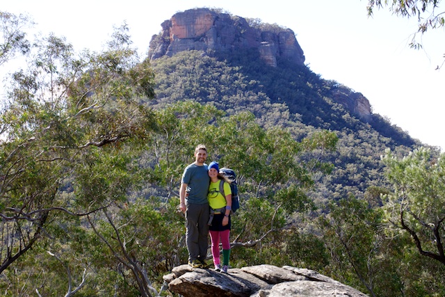
Pantoneys Crown is an isolated massif on the western edge of the Blue Mountains. It stands isolated in the entrance to the Capertee valley, a drum of orange sandstone cliffs standing four hundred metres about the valley floor. It’s impossible to see it without wanting to get on top. Five of us met up in Katoomba on Friday evening, and after a quick dinner drove to Ben Bullen and on to Moffats Trail. There are some steep and rocky descents on the trail, not advisable in the darkness, so we pulled up on a flat hilltop and camped beside the track.
The morning dawned bright and clear. One the advantages of being on the western side of the mountains is the rain shadow effect. While our friends back in Sydney dodged showers all weekend we had a warm and sunny Saturday morning and then a day and a half overcast but without a drop of rain.
Moffats trail is deeply rutted with large rocks and a couple of very steep descents, definitely 4WD only. After a short, fun drive we parked at Baal Bone Gap, from where we could see the Crown at the far end of Crown Creek, We set off at at 08.15, climbing quickly up to the top of the Baal Bone Plateau to find ourselves amongst spectacular wind-carved rock formations and with magnificent views across Crown creek to the cliffs on the other side. A gentle two and a half hours brought us to Baal Bone Point, a high block of rock almost detached from the tip of the plateau, and balanced precariously above the valley. An easy scramble through the cliff and down the point of the ridge to the saddle between the plateau and the crown. Robert was fighting some sort of infection and feeling distinctly crook, and as we reached the plateau he started to get cramps in the major leg muscles – not a good sign with the 350m ascent in front of us. We had a bet both ways on the two current theories of the causes of cramps, dosing with electrolytes and having a vigorous stretching session, before setting off up the Crown.
We were at the cliff line surprisingly soon and stopped for lunch at the bottom of the SW pass. It’s an obvious cleft in the cliffs, about 70m high and with a tree growing precariously half way up. It’s rock all the way – a series of short easy climbs with ledges in between. At one point the wall between two ledges is too high to pass packs, so we got the rope out and pack hauled. The final obstacle is a short chimney where, once again, pack-hauling is needed. At this point Robert’s leg decided to go into a major cramp and he more or less hauled himself up a knotted rope by his arms alone, before collapsing in agony at the top – a magnificent effort. We brewed a cup of tea and had a good long break, and some more electrolytes and stretching!
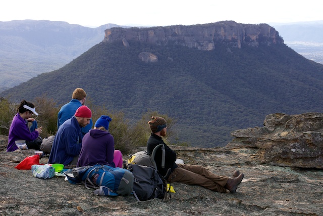
By the time we got going again it was 14.00. We followed the eastern cliff top, past intricate wind-carved pagodas and admiring the on the other wide of Crown Creek the great opening of the Capertee Valley, Mt Canobla guarding the valley entrance, and the peaks of the Wollemi beyond to the north. Eventually we reached the summit cairn for even finer views, and then dropped to a very pleasant campsite just NE of the summit, arriving about 16.00.
After getting the fire going and setting up tents we went looking for water. It’s a mistake to count on finding any up here, so we had initially planned to carry enough for two days. But after the torrential rain on Wednesday we were confident of finding water either in rock pools on the tops or down in the gullies on the western side. This meant lighter packs. Kate won the competition, with 12.5Kg including 3Kg/Ltr of water, Damon and Paul both managed 14.5Kg, again with 3Kg of water. Marty and Robert both had 19Kg, but for very different reasons. Robert was using equipment from the club’s gear locker – robust but heavy. The source of Marty’s weight became clear as the trip went on and he continued to produce delicious fresh food to share. It was like walking with the magic pudding, and much appreciated! We had a slight hitch when we set out for collect our water – Paul’s Katydyn filter decided this was the moment to break down – the second one to go in 16 years – but the water in rock pools around the summit proved crystal clear and delicious. After a good dinner and a dram of Islay malt around the campfire we made an early night of it and slept soundly through a warm and windless night.
Due to the heavy cloud cover it was still 7C at dawn, a long way from the predicted frost. The sun rose and bathed the pagodas in amazing orange light before disappearing into the clouds not to be seen again that day. We got under way about 8.00 and walked a few hundred meters to the NE pass, which comes in two flavours. One flavor is a reasonably demanding down climb of about 6m whilst the other flavor is a tight squeeze through a small cave. They both give access to the same ledge but about 50m apart. Marty popped down through the cave and appeared behind us a few minutes later having climbed up the other way. On his recommendation we lowered the packs down the climb and then squeezed the people through the cave – a two-flavour gelato.
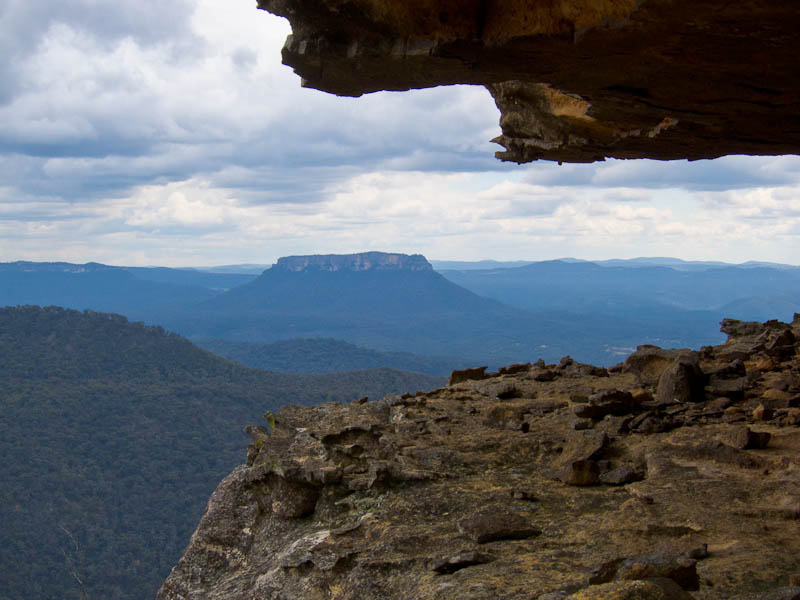
From here it’s a steep path with a couple of small down climbs. Just before the base of the cliff there is a detached pinnacle whose summit make a perfect spot for a photograph with panoramic views of the Capertee, of which we took full advantage. We traced the base of the cliffs back to the south for about a kilometer before heading down the very steep but lightly vegetated slope to where we thought we could pick up a ridge leading to the Crown Creek Trail. We stopped for morning tea in a surprising, flat grassy area surrounded by huge boulders that was quite different from any other part of the slopes and would make a delightful campsite.
After tea we set off on a bearing for the nearest point of the trail. It’s interesting country, with dense stands of Calytris, the Australian native cedar that looks as if it should be growing on a hillside above the Mediterranean rather than here, interspersed with eucalypts. But it was quite hard country to navigate, cut up with steep gullies that are an effort to cross despite being to small to show on a topo map. Finally we found ourselves directly above Crown Creek and worked our way down the precipitate final slope to reach the trail at 12.30. There was running water in Crown Creek, which showed how much rain had fallen on Wednesday as this is extraordinarily dry country and the creek is usually bone dry with any water running well below the surface.
After a short lunch break we marched back up the track to Baal Bone Gap. It’s only 5Km, but with a 300m ascent, almost all of which comes at the end, so a good solid end to the trip. As usual, age showed at the end of the day, as we watched Kate race Robert up the first hill, and met Damon coming back down the track without his pack to see if anyone wanted to give him another one to carry! But we made good time overall too and were back at the cars by 14.00 and sitting down to a meal in Katoomba at 16.00.
Thanks to everyone for a great weekend – Pantoney’s Crown is an unusually rewarding walk, with a well-defined goal you can see for most of the approach, spectacular long-distance views, the magical close-up rockscape of the pagoda country, and enough scrambling to add some excitement.
another trip notes:
My only regret about the weekend was that I could only take so few out of the 20 or so people who signed up to the trip. The lack of suitable cars for the rough 4WD tracks meant that many people had to be turned away, and only a small group of at most 6 people could be squeezed into my Forester for the slow and bumpy ride on rough dirt roads to our parking place a few kilometres from Baal Bone Gap.
The trip began as many Pantoneys Crown trips do, at Lithgow Maccas. That’s where the 6th person, Emilie, was squeezed into my already rather full car for the last leg of the journey. So after a long evening of travel we reached our parking spot on the Great Dividing Range and pitched tents near the cars on a very warm Maundy Thursday evening.
The next morning began as every morning on a Blue Mountains bushwalk should, with a cup of tea. It was already very warm as we set off by foot along a very rough and steep 4WD trail, and we were already hot and thirsty by the time we reached the pressure reducing station at Baal Bone Gap. This was the last sure water source for the next couple of days so we filled our bottles to the maximum that everyone could comfortably carry. The park ranger was parked at Baal Bone Gap and he came over for a chat.
The walking from Baal Bone Gap to Baal Bone Point was spectacular, with views of the Blue Rocks, Red Rocks, Pantoneys Crown and the Wollemi Wilderness far away on the other side of the Capertee Valley. It was quite warm with a dry wind blowing and we made heavy inroads into our already dwindling water supply. By the time we stopped for lunch in a shady spot not far from Baal Bone Point we had already consumed about a litre each. At lunch, Candice consumed an entire tin of salmon and not much to go with it, and then later in the afternoon confessed to not feeling very well.
There were some spectacular views from Baal Bone Point itself, and the rope was used for pack passing for the steep descent off here. Ahead loomed Pantoneys Crown, the prospect of a steep hot climb to get to the summit plateau, but the promise of a nice campsite once we got there. It was gentle walking at first, but the looming cliffs drew closer and sooner or later we would need to toil that steep slope. It became steep and hot climbing until at last we reached the base of sheer cliffs, and I declared to the group that at last we had managed to climb all the way to the bottom of the steep bit.
Then began the rock scrambling. From the bottom it looked harder than it is, although it was very steep. Some airy rock scrambling sections, then a ledge with a stunning view, and then finally we emerged on the plateau of Pantoneys Crown itself. The views were stupendous and not far away was a cool shady campsite. We put up tents and Savannah and Candice stayed at camp while the rest of us went in search of water. Fortunately we didn’t return with empty bottles, although they were filled with rather stagnant and muddy water, decidedly brown in colour. But at least it was wet. It would do for tea and cooking dinner, and allowed us to keep our dwindling supply of clean clear water for drinking the following day.
Joseph had developed some painful blisters, and time at camp would be utilized to air them, clean them and tape them up. He hobbled around the camp on what were very sore feet.
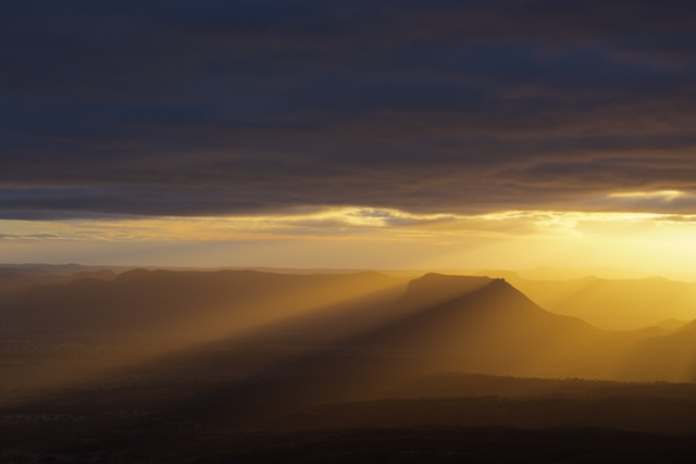
After our long and fortunately fruitful search for dirty water there was just enough time left to go to the many vantage points to witness the spectacular fiery sunset, with its soft and long evening rays of sunshine burnishing the landscape in golden green and orange hues.
We were all fairly tired so after a good meal made with muddy water we retired for the night, and the next day promised lots more spectacular climbing.
The morning dawned cloudy and much cooler, and this provided some welcome relief from the heat and meant our water consumption could be slowed down. I held out hope that we would find some clear pools of water in Crown Creek at lunch time, but nonetheless we carried the muddy water with us, as well as our remaining supplies of clean drinking water, just in case.
We passed the summit cairn and signed the logbook, which dated back to only 2006. We were the first party since October 2017 to sign it. I lamented the fact that in 2000, a club member took away the old logbook that had been there since the late 1970s.
We descended the northern end of the Crown, and some pack passing was needed for the steep bits. And once we were down off the Crown itself, there was quite a bit of walking and navigating on mixed terrain to find the ridge down to Crown Creek. The cloud cover had broken up and it was once again very warm and dry. At last the steep descent to Crown Creek began and from high up we spotted pools of clean water. So we were saved! We had a well earned long and relaxing lunch by the creek, which was shallow and only just flowing, but with abundant water compared to what we had had until now. Despite the fact that the water was crystal clear, it had a fairly hard flavour, as if it were old groundwater, and thus it didn’t quench our thirsts quite as fully as it might have. But water is wet, and better than air for drinking, and we drank and refilled and fattened bladders and filled bottles with as much as we could carry.
Within a few minutes of setting off from our lunch spot we had sweated out most of the water we’d just consumed, as the climb up Point Cameron was relentlessly steep and in the full face of the afternoon sun. The final ascent through the cliffs was breathtakingly steep but nonetheless quite negotiable with all care taken not to dislodge rocks. A devious climbing route underneath a chockstone followed by a steep chute led us to the summit of Point Cameron, the surrounding area burnt and charred by a recent bushfire. We found open flat campspots among the charred tree trunks and after setting up tents we had a couple of hours to relax and rest and watch the sun go down.
The sunset from Point Cameron was truly splendid. Pantoneys Crown stood there in prominence framed in the golden sunlight, and the chains of cliff lines to left, right and in front were lit in gold and orange. Each of us found prominent ledges to sit on and be photographed, and our cameras clicked away. The sun went down and we returned to camp to cook our meals, enjoy cups of tea made from the precious water, and have some conversation around the small campfire.
The subsequent sunrise was, if anything, even more beautiful. To my surprise in this dry weather, the valley was cloaked in a veil of translucent mist, and in the distance low cloud sat snugly in shallow valleys, and spilled like ethereal waterfalls from one valley to the next. We returned to our favourite vantage points and drank in the marvellous scene around and below us.
Our water supplies were low and the day was warming up again so we set off towards McLean Pass and the waiting car further beyond. As with all the walking on this trip, the scenery along the way was splendid, with views of endless cliff lines and expansive valleys. There were several more ups and downs, and our water had almost completely run out when finally we reached a fire trail from where it was only a 2km walk back to the car and the large water container inside it.
After a welcome lunch and long drink by the car, we took to the slow bumpy roads again, with Savannah in the back with the packs, then dropped Emilie at Lithgow and continued our journey back to Sydney.
The words of everyone in the emails that went around once we were all home sums up what the trip meant to everyone, and yes, it was a truly memorable weekend, spectacular and beautiful, challenging and rewarding, with a great group of people. One of the best Blue Mountains bushwalks in years.
Alerts
Wollemi National Park
Closed areas: Part of Wollemi National Park, around the Nullo East trail is closed for ground pest control operations between the 6th and 10th of May 2024
A ground pest control program will be undertaken in Wollemi National Park around the Nullo East trail between 5am on the 6th of May, until 5pm on the 10th of May 2024. The Nullo East trail is closed to public access during this period. Penalties apply for non-compliance. For more information, contact the NPWS Mudgee Office at (02) 6370 9000
Closed areas: Glow Worm Tunnel closure
The Glow Worm Tunnel visitor precinct and associated walking tracks are currently closed for upgrade works, and will re-open Saturday 1 June.
This closure includes:
- Glow Worm Tunnel carpark
- Glow Worm Tunnel walking track
- Pagoda track (Old Coach track)
- Glow Worm Tunnel to Newnes walking track (to ‘four-ways’ intersection).
- Dry Canyon access track (Wolgan View canyon).
Penalties apply for non-compliance. For more information, contact the local NPWS office on 02 6336 6200.
Closed areas: Newnes Campground Pedestrian Access Only
Newnes campground is available for walk-in access only. The campground is remote and can only be accessed by long walks via the Old Coach Road or the Pipeline Track.
Campers need to be fully self-sufficient and carry all supplies including drinking water. Campers are strongly advised to complete a trip intention form for their safety. Pack it in, pack it out – please take all rubbish with you when you leave.
There is no road access due to the Wolgan Road collapse and continuing land slip risk at Wolgan Gap. Wolgan Road is managed by Lithgow Council.
Penalties apply for non-compliance. For more information, contact the local NPWS office on 02 6336 6200
Closed areas: Wheeny Creek campground closed due to flooding
Wheeny Creek campground will be closed from Wednesday 3 April 2024 until Monday 29 April 2024, due to excessive flooding and storm damage.
For more information, contact the local park office on (02) 4720 6200.
Closed areas: Glow Worm Tunnel Road and Camp Road roadside vegetation management
NPWS will be implementing roadside vegetation management during April and May 2024 in the Gardens of Stone State Conservation Area and Wollemi National Park.
Roads affected are:
• Camp Road between Eastern Boundary Road and Forest Camp:
o Closed to the public for approximately 1 week.
o Access to Forest Camp via Eastern Boundary Road
• Glowworm Tunnel Road from Bungleboori Day Use Area to Galah Mountain Road:
o Traffic control will be in place for approximately 3 to 4 weeks. One-way traffic only. Expect short delays.
Please use caution when driving and obey all signs and directions.
Penalties apply for non-compliance. For more information, contact the NPWS Kanangra office on 6336 6200.
Closed areas: Roadworks along Glow Worm Tunnel Road
Minor roadworks along Glow Worm Tunnel Road will take place from Wednesday 10 January to Friday 3 May 2024. This includes small sections of State Mine Gully Road and Old Bells Line of Road. The road won't be closed, however there will be traffic management in place to guide vehicles around roadworks.
Please exercise caution when driving in the area. For more information, contact the local NPWS office.
Closed areas: Roads closed due to flood damage
The following roads in this park are closed due to storm and flood damage:
- California trail - closed until late June 2024
- Martindale trail - closed until June 2024
- California Hut - closed until late June 2024
Penalties apply for non-compliance. For more information, contact the NPWS Bulga area office.
Closed areas: Glow Worm to Newnes walking track
The section from Glow Worm Tunnel to Newnes walking track from the Glow Worm tunnel exit to the ‘four-ways’ intersection, Wolgan Valley, will remain closed until further notice. This closure is due to significant rainfall, geohazards and to allow track work.
Penalties apply for non-compliance. For more information, contact the local NPWS office on 02 6336 6200.
Other planned events: Notice of ongoing 1080 baiting program
NSW National Parks and Wildlife Service (NPWS) is conducting ongoing ground baiting program from Thursday 2 November 2023 to Wednesday 1 May 2024 in the following areas:
- Abercrombie River National Park
- Abercrombie River State Conservation Area
- Kanangra-Boyd National Park
- Blue Mountains National Park (southern section)
- Wollemi National Park (Wolgan Valley area)
- Gardens of Stone National Park
- Jenolan Karst Conservation Area
- Turon National Park
- Marrangaroo National Park
The program is designed to minimise predator impacts on wildlife, especially threatened species, and to minimise impact of wild dogs on neighbouring stock.
Signs will be placed at the entry to the baiting location. Domestic pets are not permitted in NSW National Parks managed lands. Pets and working dogs may be affected (1080 is lethal to cats and dogs). Pets and working dogs must be restrained or muzzled in the vicinity and must not enter the baiting location. In the event of accidental poisoning seek immediate veterinary assistance.
For more information, contact the NPWS Kanangra area office at Oberon on 02 6336 6200.
Closed areas: Wheeny Creek campground - Boobook section closed
The Boobook campground and picnic area within Wheeny Creek campground has permanently closed due to flood damage. Please note that the rest of Wheeny Creek precinct remains open for bookings. Penalties apply for non-compliance. For more information, contact the local NPWS office on 4720-6200.