

Info
walking distance: 6.5 kmduration: 10:09 h
walking: 3:42 h
elevation diff: 523 m
location: wollemi
driving distance: km
driving time: h
water available: yes
parking: -33.2033,150.5549

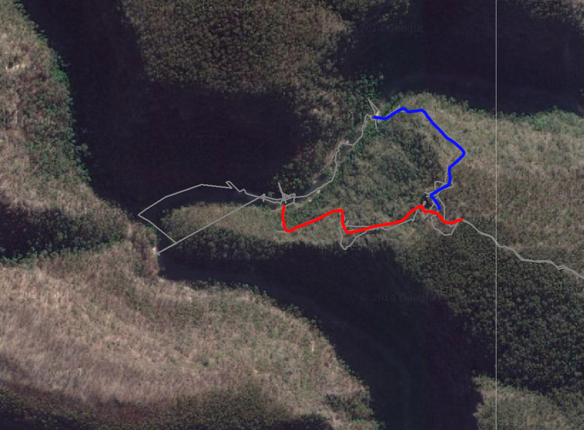
gps tracks
Max elevation: 634 m
Min elevation: 134 m
Total climbing: 888 m
Total time: 09:20:17
Max elevation: 636 m
Min elevation: 91 m
Total climbing: 2886 m
Total time: 06:38:11
Video
Track notes
TRACK NOTES:
hike down took 4:30h. from 420m to 160m…… (BLUE) (from lookout)
Alerts
Wollemi National Park
Closed areas: Pipeline Track Closure
The Pipeline Walking Track will be closed from 2pm Thursday 4 April 2024 to 5pm Wednesday 17 April 2024 due to heavy rainfall.
This area will re-open as soon as it is safe.
Remember, it’s never safe to drive, ride or walk through flood waters, so you’ll need to reschedule your visit and avoid travel through areas in this park. Check Live Traffic NSW for up-to-date information about road closures. For assistance during severe weather visit the NSW SES website. In life-threatening situations call emergency services on Triple Zero (000).
Penalties apply for non-compliance. For more information, contact the NPWS Kanangra area office at Oberon on 02 6336 6200.
Closed areas: Newnes Campground Pedestrian Access Only
Newnes campground is available for walk-in access only. The campground is remote and can only be accessed by long walks via the Old Coach Road.
Campers need to be fully self-sufficient and carry all supplies including drinking water. Campers are strongly advised to complete a trip intention form for their safety. Pack it in, pack it out – please take all rubbish with you when you leave.
There is no road access due to the Wolgan Road collapse and continuing land slip risk at Wolgan Gap. Wolgan Road is managed by Lithgow Council.
Penalties apply for non-compliance. For more information, contact the local NPWS office on 02 6336 6200.
Closed areas: Colo Meroo campground closed due to flooding
Colo Meroo campground will be closed from Wednesday 3 April 2024 until Monday 29 April 2024, due to flooding impacts and subsequent repairs.
For more information, contact the local park office on (02) 4720 6200.
Closed areas: Wheeny Creek campground closed due to flooding
Wheeny Creek campground will be closed from Wednesday 3 April 2024 until Monday 29 April 2024, due to excessive flooding and storm damage.
For more information, contact the local park office on (02) 4720 6200.
Closed areas: Glow Worm Tunnel Road and Camp Road roadside vegetation management
NPWS will be implementing roadside vegetation management during April and May 2024 in the Gardens of Stone State Conservation Area and Wollemi National Park.
Roads affected are:
• Camp Road between Eastern Boundary Road and Forest Camp:
o Closed to the public for approximately 1 week.
o Access to Forest Camp via Eastern Boundary Road
• Glowworm Tunnel Road from Bungleboori Day Use Area to Galah Mountain Road:
o Traffic control will be in place for approximately 3 to 4 weeks. One-way traffic only. Expect short delays.
Please use caution when driving and obey all signs and directions.
Penalties apply for non-compliance. For more information, contact the NPWS Kanangra office on 6336 6200.
Closed areas: Glow Worm Tunnel closure
The Glow Worm Tunnel visitor precinct and associated walking tracks currently closed for upgrade works, and will re-open Saturday 1 June.
This closure includes:
- Glow Worm Tunnel carpark
- Glow Worm Tunnel walking track
- Pagoda track (Old Coach track)
- Glow Worm Tunnel to Newnes walking track (to ‘four-ways’ intersection).
- Dry Canyon access track (Wolgan View canyon).
Penalties apply for non-compliance. For more information, contact the local NPWS office on 02 6336 6200.
Closed areas: Roadworks along Glow Worm Tunnel Road
Minor roadworks along Glow Worm Tunnel Road will take place from Wednesday 10 January to Friday 3 May 2024. This includes small sections of State Mine Gully Road and Old Bells Line of Road. The road won't be closed, however there will be traffic management in place to guide vehicles around roadworks.
Please exercise caution when driving in the area. For more information, contact the local NPWS office.
Closed areas: Roads closed due to flood damage
The following roads in this park are closed due to storm and flood damage:
- California trail - closed until late June 2024
- Martindale trail - closed until June 2024
- California Hut - closed until late June 2024
Penalties apply for non-compliance. For more information, contact the NPWS Bulga area office.
Closed areas: Glow Worm to Newnes walking track
The section from Glow Worm Tunnel to Newnes walking track from the Glow Worm tunnel exit to the ‘four-ways’ intersection, Wolgan Valley, will remain closed until further notice. This closure is due to significant rainfall, geohazards and to allow track work.
Penalties apply for non-compliance. For more information, contact the local NPWS office on 02 6336 6200.
Other planned events: Notice of ongoing 1080 baiting program
NSW National Parks and Wildlife Service (NPWS) is conducting ongoing ground baiting program from Thursday 2 November 2023 to Wednesday 1 May 2024 in the following areas:
- Abercrombie River National Park
- Abercrombie River State Conservation Area
- Kanangra-Boyd National Park
- Blue Mountains National Park (southern section)
- Wollemi National Park (Wolgan Valley area)
- Gardens of Stone National Park
- Jenolan Karst Conservation Area
- Turon National Park
- Marrangaroo National Park
The program is designed to minimise predator impacts on wildlife, especially threatened species, and to minimise impact of wild dogs on neighbouring stock.
Signs will be placed at the entry to the baiting location. Domestic pets are not permitted in NSW National Parks managed lands. Pets and working dogs may be affected (1080 is lethal to cats and dogs). Pets and working dogs must be restrained or muzzled in the vicinity and must not enter the baiting location. In the event of accidental poisoning seek immediate veterinary assistance.
For more information, contact the NPWS Kanangra area office at Oberon on 02 6336 6200.
Closed areas: Wheeny Creek campground - Boobook section closed
The Boobook campground and picnic area within Wheeny Creek campground has permanently closed due to flood damage. Please note that the rest of Wheeny Creek precinct remains open for bookings. Penalties apply for non-compliance. For more information, contact the local NPWS office on 4720-6200.
Wollemi Flora Reserve
Closed areas: Roads closed due to flood damage
The following roads in this park are closed due to storm and flood damage:
- California trail - closed until late June 2024
- Martindale trail - closed until June 2024
- California Hut - closed until late June 2024
Penalties apply for non-compliance. For more information, contact the NPWS Bulga area office.