
Info
walking distance: 14.8 kmduration: 0:00 h
walking: 0:00 h
elevation diff: m
location: Nattai NP
driving distance: 140 km
driving time: 1:45 h
water available:
parking: -34.3090,150.2637
gps tracks
Max elevation: 0 m
Min elevation: 0 m
Total climbing: 0 m
Video
Track notes
| Time: | 7 hrs |
| Distance: | 16km |
| Fitness: | EM |
| Skill: | M |
| Ascent: | 80m |
| Maps: | LPI Hilltop 8929-II-N 1:25000 |
| Notes: | Print-friendly notes (opens in new window) |
http://bushwalkingnsw.com/walk.php?nid=826
Introduction
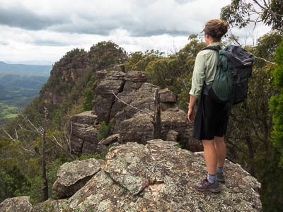
The route crosses many of these domes
Bonnum Pic lies near the end of a spectacular knife-edge ridge that juts out into the Wollondilly Valley in NAttai NP. The walk to the Pic has a bit of everything – valley views, on-track walking, off-track walking, rock scrambling and route finding. It is best in the cooler months as it is along the ridges, and there is accessible water only if there has been recent rain.
While reaching the Pic involves rock scrambling and route finding, because this is an out and back walk, parties can go as far as they are comfortable before turning back. There are great views from many places once the cliffs are reached.
Access
If you are coming from Sydney, take the turnoff off the Hume HIghway to Mittagong, and turn right at the Y-intersection in the middle of town on to the Old Hume Highway. About a kilometre after crossing over the main highway, turn right on to Wombeyan Caves Rd, and reset your speedo.
Alternatively, if you are coming from the south, take the Old Hume Highway exit near Mittagong, turn left, and then right after a kilometre on to Wombeyan Caves Rd.
From the Wombeyan Caves Rd turn-off, drive for 17.0km and turn right on to Wanganderry Rd. This is gravel and dirt, though it should be trafficable to 2wd cars most of the time. It is 5.3km from the turn-off to the stock yards and gate. Park here in the turning circle.
Track notes
From 03 Mar 2013, last checked 03 Mar 2013
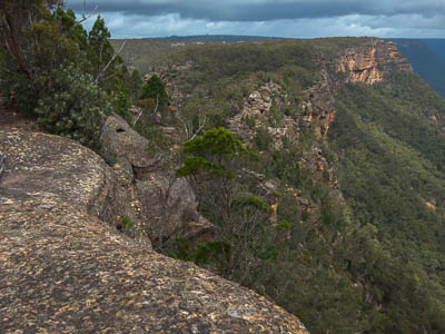
Looking out to the Pic
Go through the gate, making sure you leave it as you found it.
One option is to turn right and follow the fence line around the outside of the private property. This route dips up and down as it crosses the tops of a couple of small creeks.
Alternatively, it may be better to walk down the road for 500m to a National Parks sign, and turn right onto a (hopefully) marked track heading east. This crosses a deeper creek, and rejoins the fence line after the larger creek crossing above.
Either way, from this point, follow the fenceline roughly north, past a dam inside the fence, to a large clearing. Continue directly across the clearing to a couple of taped trees and thence to the edge of the bush. Pick up the fire trail that heads into the bush to the north, along the ridge. The fire trail and subsequent track is taped, mostly with pink tape, though some care needs to be taken in places as the track can be a little vague.
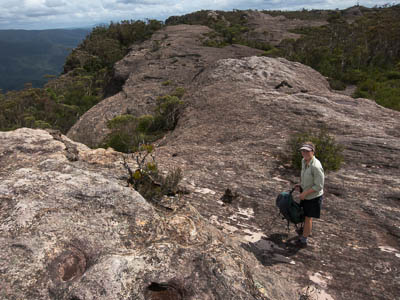
The track follows the obvious ridge line out to the western cliff edge, on the west side of Bonnum Pic creek, and the forest opens out into heath, and great views of the Burnt Creek Valley. From here the track becomes less distinct, though it continues to be marked with pink tape and the occasional cairn. The terrain is now a mixture of open forest, and spectacular dome-shaped rock formations which offer great walking and scenery.
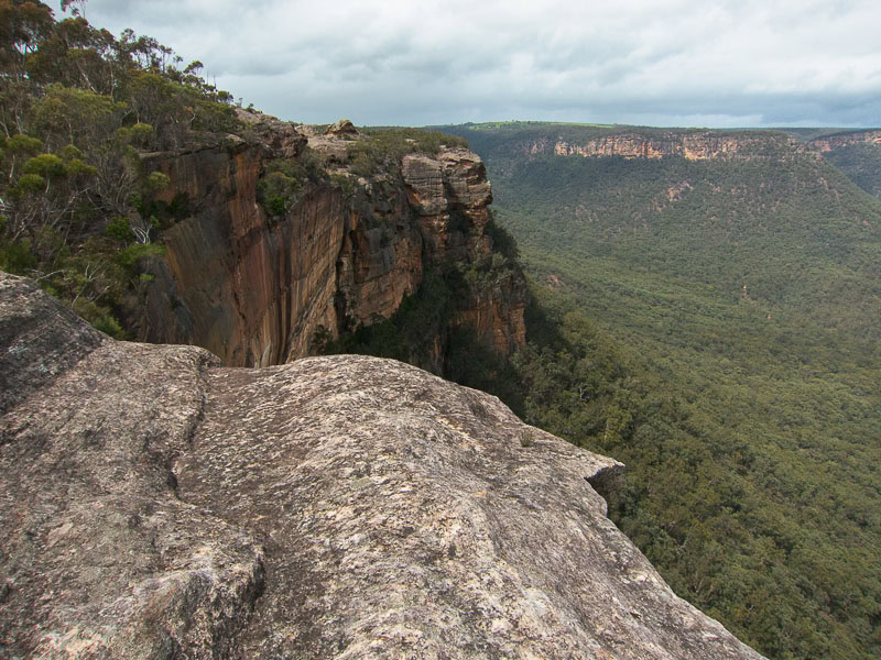
Clifflines on the route
The taped route ends where the cliffline swings from north-west to north-east, and experience with off-track walking and route-finding is required from here on. Regardless, the walk to this point is worthwhile in itself for the views.
From here to the Pic, the route generally stays close to the cliff edge. There are occasional cairns and tape markings, though not enough to rely on for navigation.
There is a scramble down beside the small creek at the narrowest point on the ridge on the map. This creek in fact tumbles into the valley on the western side, not the eastern as marked on the map, though mostly it will not be flowing. There is also a bit of a scramble up the other side. From there it is pretty much a case of follow your nose. The route keeps to the skyline except for one part where it drops below the top cliffs on the eastern side.
The Pic is the second last bump on the ridge, and offers great views of the Wollondilly Valley, Lake Burragorang, the Wanganderry Walls and even Mt Colong. The final bump requires an exposed scramble across a very narrow section of the ridge to reach.
After a break, return the way you came.
Although I have been put off for many years by the concern that it was difficult to access, it was not all that hard at all really. Most of the walking is on undulating ground with no big climbs. It’s a good longish day walk. But of course there is a catch! The track fades after about 2.5km and then becomes a navigational exercise with careful observation needed to follow the faint and overgrown route all the way to the end of the Pic. Although we were only a party of 2, I later found out that 2 more members had emailed me at 12am Friday night requesting to sign up! Sadly I got the message too late..(Sorry people, but I don’t normally check my email at 6am!), so they missed out, so there is a message to prospective walkers, do try and give more notice than that to join a walk!
So, at about 10am Damon and I set off from the start of the track , off a farm road about 25km out from Mittagong. Signage from NPWS confirmed the trail head, and my fears of not finding the beginning of the track were put to rest. Although this is not really a popular walk, we were surprised when a group of 21 walkers from “Sydney Explorers” showed up. They had changed plans from doing another walk in Morton National Park. They were friendly enough, but their large party meant we were better off leaving them behind us, and after an hour or so, we were quite a distance ahead. They never made it all the way out to the end.
It was a great day to walk, although it got pretty hot later on, maybe 27C? I wouldn’t recommend doing it in warmer weather than that, as there is a lot of exposed rock which makes the place bake. The trail was fairly easy to follow until the lookout over the Wollondilly Valley. Then it turned from west to north, over interesting rock domes with wind caves in them. Then the route needed constant attention, as sometimes the markers were not easy to spot, but as a rule of thumb, you just needed to stay west toward the cliff lines to find it again. Needless to say the views all the way were superb.
About 2 hours into the walk, the route dipped into a shady gully where you dropped off an escarpment past a little camping cave. In winter there looks like there might be a running stream there, but not so in summer. Then the way became a bit more technical with boulder scrambles needed to gain the main peak. Care had to be taken as a fall could be fatal, there were a lot of big drop offs around!
A hot and sweaty climb saw us gain the Pic summit at around 1.45pm. The views in all directions were fantastic! Damon took the challenge of getting right out to the end “lump” beyond the summit, which involves getting down a steep rocky ramp onto a ledge . The catch is if you make a mistake on either side of it, there is about 150m of air below! Well that’s my guess, I was a bit overheated and feeling somewhat washed out, so I wasn’t about to try. I set up a rope for his return, he reported another spot on the “lump” where there was a half metre crossing with more drops on both sides. But if you are looking for thrills, this is your spot!
After some lunch we headed back home. The heat of the day had really kicked in by now, and our water supplies began running low. A cold lemon drink is all I could think of now! Even though we took care, we still lost the way a few times, but soon found it just as easily. After exploring a few of the domes and wind caves, we wandered back along the trail. I then thought of taking an easier route following a farm fenceline, but (of course) this turned out to be trickier than expected. We had to crawl through at least 3 barbed wire fences to get back to the cars! My advice? Just take the NPWS route through the gully!
We got back to the cars by 5.30pm. The other group were long gone. But we enjoyed a well made local Portugese Hamburger and that wonderful cold lemon Solo in Mittagong before heading back to Sydney.
It’s a great place that I would like to go back to, but in cooler weather next time!